Yes,where you gonna be in the next 24 hours possible to predict by the power of Geospatial/Location Based Technologies.

Sometimes ago I was discussing with some folks and nurturing this idea of carrying out a research on predicting where you gonna be in the shortest while by monitoring and correlating your social and professional activities for a period of time.
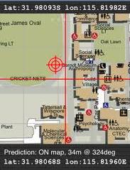
Here we are!, some UK researchers have gone ahead of me to develop the algorithm that can predict where you will be in the next 24 hours to some good accuracy.
This is awesome, yeah like I always said, integrating geospatial/location based technologies,social networking technologies and GSM technologies the prediction is greatly possible even to some meter accuracy.
According to the research, where you will be in the next 24 hours can be predicted to a km accuracy based only on your past location information. Adding the data about where your friends are, the accuracy drops to about 20 meters. Now when you add sensor data from your phone, your social networks, online shopping and so on, actually a meter accuracy is undoubtedly possible.
Folks!, let’s talk less about location privacy in this regard, of course you have no privacy as long as you are in these web things, but let us embrace the positive side of this research, just to make your life and those of others more interesting.

#Business


Next article

Great service has been launched in England and Wales by Shoothill – a software developers specialized in Microsoft services (e.g Bing Map+Silverlight for that new service). FloodAlerts is a free to use web mapping service using data provided by the Environment Agency. It is the first service (as far I’m know) that graphically represents the flood risk with every 15 minutes updates.
Of course one could have objections how the hell would governmental agency have such a high resolution data for whole two countries… Nonetheless the result is pretty amazing. And even more amazing (and award winning – The Guardian Innovation Nation Awards) is their Facebook app where users can register any location they want to monitor and if a relevant alert is issued, they then receive a notification on their Facebook wall and to their email address. Simple and simply great idea. I love it.
Check it out:

source: Shoothill