
 Take a quick look at the article below and see reasons why Google Maps API is the most popular API on the web and invariably rules the web. Google Maps API is so formidable that Apple Maps and Bing Maps are seriously not finding their stand at all.
The article of Ajay Ohri, suggests the reasons why Google Maps API is the champion of all location APIs.
The Google Maps API consists of the following
The Google Directions API is a service that calculates directions between locations using an HTTP request. You can search for directions for several modes of transportation, include transit, driving, walking or cycling. Directions may specify origins, destinations and waypoints either as text strings (e.g. “Chicago, IL” or “Darwin, NT, Australia”) or as latitude/longitude coordinates.
The Google Distance Matrix API is a service that provides travel distance and time for a matrix of origins and destinations. The information returned is based on the recommended route between start and end points, as calculated by the Google Maps API, and consists of rows containingduration and distance values for each pair.
The Elevation API provides elevation data for all locations on the surface of the earth, including depth locations on the ocean floor (which return negative values). With the Elevation API, you can develop hiking and biking applications, mobile positioning applications, or low resolution surveying applications.
This service is generally designed for geocoding static (known in advance) addresses for placement of application content on a map; this service is not designed to respond in real time to user input, for example. Use of the Google Geocoding API is subject to a query limit of 2,500 geolocation requests per day. (User of Google Maps API for Business may perform up to 100,000 requests per day.) This limit is enforced to prevent abuse and/or repurposing of the Geocoding API, and this limit may be changed in the future without notice.
A very nice documentation is available here-https://developers.google.com/maps/documentation/webservices/ You can also use it as a starting tutorial for web services.
The Google Places API, which can be used to find detailed information about places across a wide range of categories. Backed by the same database used by Google Maps and Google+ Local, the Google Places API features over 80 million businesses. But it is experimental and so you have been warned!
If you are a ninja developer you can take part in the Google Places API challengehttps://developers.google.com/places/challenge/. The Google Places API allows you to tailor your place search results by including your own places and affecting place rankings with Place Bumps. Developers of the best apps will win a VIP trip to Google I/O 2013 where your app will be showcased!
Google Maps Image APIs are of two types
The Google Static Maps API lets you embed a Google Maps image on your web page without requiring JavaScript or any dynamic page loading. The Google Static Map service creates your map based on URL parameters sent through a standard HTTP request and returns the map as an image you can display on your web page.
The Google Street View Image API lets you embed a static (non-interactive) Street View panorama or thumbnail into your web page, without the use of JavaScript. The viewport is defined with URL parameters sent through a standard HTTP request, and is returned as a static image.
Google Earth
The Google Earth API is modeled after KML, so you should also consult Google’s KML documentation
KML is a file format used to display geographic data in an Earth browser such as Google Earth, Google Maps, and Google Maps for mobile. KML uses a tag-based structure with nested elements and attributes and is based on the XML standard.
Check out the video below for more information on the exciting stuffs of Google Maps API.
Source : programmableweb.com

#Business


Next article
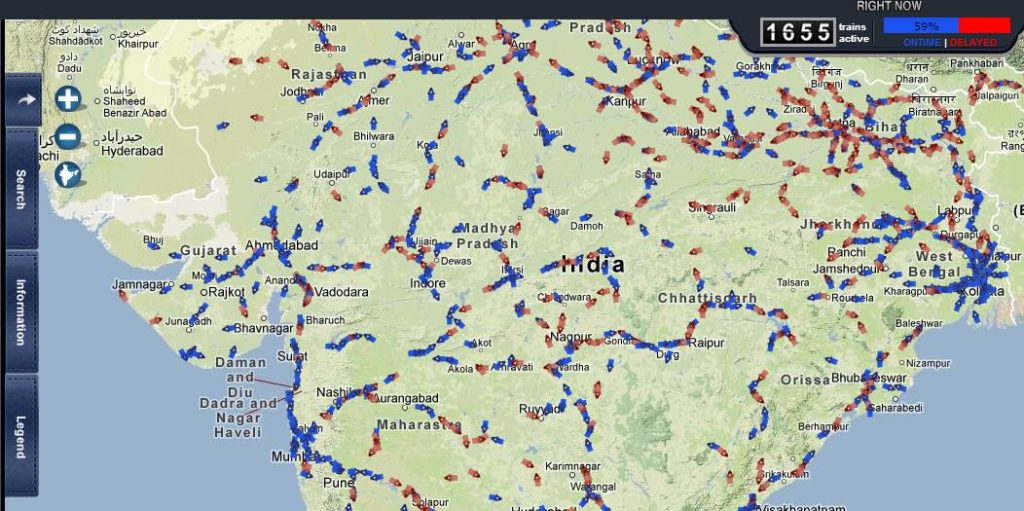
Indian Railways has just launched a new service called RailRadar to track a train’s exact location on a map. RailRadar is an online app where one can find the exact geographical location of about 6,500 trains on a Google map on real-time basis. The system enables a colour code method as trains highlighted in blue indicate those that are running on time while the red markers indicate the trains that are delayed or behind schedule.
To find out where your train is, simply search for its name or number and RailRadar will spot it for you. You can also find trains by entering the name of the station. One might think that it’s nothing fancy but when you look at the numbers India has the largest rail networks in the world — it operates more than 10,000 trains everyday and when you look at the top-right of the image you’ll notice that at this particular moment when I write the post only 60% of all trains are on time….
At this time there is no smartphone app but surely it’s just a matter of time.

source: The Economic Times