
With over a third of the world’s population in some form of lockdown and more than half a million people infected by Coronavirus, Governments across the world are scrambling to come up with solutions to mitigate and contain the spread of COVID-19. One of the solutions that Governments are exploring to contain the spread of coronavirus is the use of location data to monitor the movements of its citizens.
With the lives of millions of people across the world at stake, it is easy to understand the lure of location data in the fight against the coronavirus pandemic. The use of location data to monitor the population might improve the ability of governments and research organizations to control the spread of the virus. While it is necessary for governments to curtail/limit individual freedom in order to tackle the pandemic, the use of (location) data to monitor the population at such a scale has consequences for data protection, privacy, and dare I say, the future of our society.
Location Surveillance across the world
Before we discuss whether it’s “okay” for Governments to do whatever it takes it to contain the virus including the use of location data at scale, let us first take a look at what has been done so far and what is being discussed.
China: When news emerged earlier last month that the Chinese governmental departments have co-developed and launched an app that informs its users whether they have been in close contact with someone infected by COVID-19, it didn’t come as a surprise to many that the government had such capabilities and was willing to inform its citizens that their movements were being monitored. This wasn’t the only tool that the Chinese government has deployed in its fight against coronavirus. In an effect to better understand the movements of its residences, local governments across at least 15 provinces and cities asked visitors to office buildings, shopping malls, residential compounds, and metro systems to scan QR codes using their mobile phones. Foursquare meets governmental surveillance!
Just as the virus originated in China and spread across the world, the idea of using location surveillance techniques is now slowly going global.
Israel: Israel’s Prime Minister has already authorized the use of cellphone location data (collected from Israeli telecom providers) to identify citizens who came into close contact with known virus carriers and send them text messages instructing them to self-quarantine themselves immediately.
United Kingdom: Just days ago, the U.K.’s Information Commissioner’s Office (data and privacy authority) clarified that the Government can legally use personal data from people’s mobile phones if it helps fight the spread of coronavirus. It is worth noting that the UK government was already in talks with BT (UK mobile operator with more than 20 million customers) to potentially use anonymous location and usage data to create movement maps, with a 12- to 24-hour delay, to understand whether the people are abiding by the government’s orders to stay home.
Italy, Austria and Germany: Telecom providers in Italy, Austria and Germany are sharing anonymous and aggregated data with health authorities in these countries and helping them map concentrations and movements of customers in ‘hot zones’ where COVID-19 has taken hold. It is to be mentioned that this data is fully legally and complies with Europe’s privacy laws.
United States: According to reports from the Washington Post, the US government is in active talks with Facebook, Google among other tech companies to explore the use of location data gathered from smartphones to map the spread of the infection and also potentially tracking whether people are keeping one another at safe distances.
Worldwide: All these measures mentioned above are at the national level. What happens once you leave the national border? Enter GSMA, an international standard-setting body for the mobile phone industry that represents the interests of 750 mobile phone operators and vendors across the world. The Guardian reported that GSMA had discussed the possibility of creating a global data-sharing system that could track individuals around the world.
If we are to allow access to location data at this scale, shouldn’t be at least be sure it works?
Before we dive into whether it is ethical (and legal) for Governments to be using location data at scale to combat the pandemic, let us first explore whether these tools would serve the purpose.
If you consider the efforts of various governments across the world, two levels of location surveillance are evident.
- Level 1 – Anonymous and Aggregated data
- Level 2 – Individual data
Level 1 – Anonymous and Aggregated data
Aggregated location data (whether it’s from telecom providers or via smartphone apps) give authorities a sense of
- (A) Hot spots
- (B) Movement patterns
(A) Hot Spots
Hot spots i.e. understanding where a large number of people are gathered and how it changes over the course of the day can give authorities valuable insight into whether their social distancing efforts are actually working. If authorities repeatedly notice a large gathering of people at a particular time at a particular location then it’s easy to imagine the local law enforcement is able to use this data to prevent it from happening the next time around.
Is this going to be useful? It is estimated by 2019, an estimated 67% of the population worldwide will have a mobile phone. That means a third of the population isn’t represented in these hot spot maps! It might not be 100% representative but it might give authorities a chance to focus their enforcement activities instead of patrolling the entire city.
(B) Movement Patterns
At a more granular level, anonymous and aggregated data can be used to create movement patterns. One could use this information to understand how far people are traveling from their homes, how many different people they encounter in their daily lives, etc.
Is this data interesting? Sure, absolutely! But is it going to be useful? One suggestion is that authorities could enforce stricter checks in neighborhoods where people are evidently breaking the curfew and moving around more than necessary. Another suggestion is that authorities could use movement patterns to track future flare-ups of the virus. I’m not sure whether these suggestions are useful and if they are absolutely necessary.
Here is the trouble with movement patterns derived from precise location data – it is not anonymous. New York Times as part of its “Times Privacy Project” analyzed a comprehensive set of mobile phone records. Comprehensive as in 50 billion location pings from the phones of more than 12 million Americans. In spite of the data being pseudonymized, the journalists were able to identify several well-known individuals debunking the claim that precise location data can be anonymized. Just removing personal identifiers from precise location data doesn’t make it anonymous. if you haven’t read that report, I suggest that you stop everything else that you are doing including reading this blog and read that! (Read: Twelve Million Phones, One Dataset, Zero Privacy)
Level 2 – Individual data
Let us assume that we as a society chose to give up our digital rights for the greater good and allow our Governments to access our precise location data at all times. So what can they do with it and is it going to be helpful in the fight against coronavirus?
If the Government is aware of your location at all times then they could potentially warn you when you come in contact with an infected person. Sounds rather useful, right? This is similar to what the “close contact detector” app in China (and elsewhere) aims to achieve. In theory, it sounds wonderful. But are location data records precise enough to actually determine whether you were in close contact with an infected person i.e. less than 2 meters from that person? Positioning on our smartphones using GPS/GNSS is at best about 5 meters accurate and even with WiFi, Bluetooth and other sensors enabled on your smartphone, it is hard to imagine that the location data is always accurate to less than 2 meters. What happens when you don’t use a smartphone? cell site location information is only able to locate a phone within a zone of a few kilometers. So not really helpful for contact tracing.
Do the benefits (still) outweigh the concerns?
Putting aside all privacy concerns and technological limitations that might make the data less useful, are there other concerns that could potentially outweigh the benefits?
At a time when Governments are already concerned that people with minor symptoms could choose not to get tested in order to avoid isolation, could access to precise location data lead to more such concerns? Wouldn’t people avoid getting testing for coronavirus if they knew their digital lives are going to be laid bare for others? (Read: A ‘travel log’ of the times in South Korea: Mapping the movements of coronavirus carriers)
Bottomline
Location data like all data can be used for more than one purpose. Precise location data at scale might be really helpful for controlling the coronavirus pandemic but what guarantees do we have that it cannot be used to undermine democracy and human rights?
I think it is important that Governments show why such proposals are necessary and how it would work. At a time when trust in public institutions is already low and fears of “big brother” are high, we certainly need clear laws that explain what data is being collected, at what level, the purpose and objectives of data use, as well when and how the data will be erased once the analysis is complete.
Location data can be a powerful tool. It is up to us to figure out how to weigh the benefits and concerns before rushing into it something just because it is alluring.


#Business


Next article

Christopher Columbus set sail from Spain on August 3, 1492, hoping to find a trade route to Asia. After spending more than two months at sea, Columbus landed on an island in the Bahamas. But the Italian explorer thought he had reached Japan, the land of gold – because that’s what the map he was using as a reference was telling him.
Columbus is thought to have been guided by a copy of the 1491 map of the world, created by German cartographer Henricus Martellus. Measuring about 4 feet by 6.5 feet, this map showed the entire world as it was known to 15th century Europeans at that time. Likely commissioned by a royal family, the Martellus map was hand-painted on paper and glued to a canvas backing.
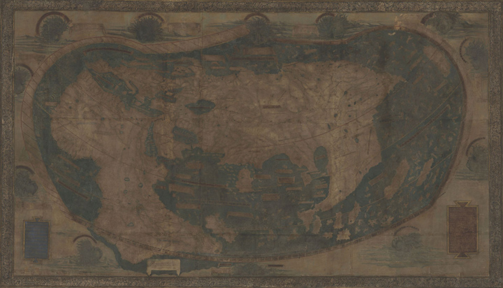
The Martellus map under natural light
Above, you can make out an oddly-shaped Africa to the left, a more or less accurate Europe and the Mediterranean Sea, and the large mass of Asia with Pacific islands to the right. The ‘New World’ was yet to be discovered by the Europeans and it wouldn’t be until 1507 that the famous Waldseemüller map would use the term ‘America’.
The Martellus map drew its influences from Marco Polo’s voyages and the trips of Portuguese explorers around the Cape of Good Hope. Unlike most other maps from that era, it did not showcase any sea monsters – thus providing a unique view into Renaissance cartography. Instead, it was loaded with text labels and descriptive legends in the Latin language.
Yale University received the Martellus map in 1962 through an anonymous donation. By that time, much of the text had become illegible, courtesy fading, water damage, over-painting, and palimpsesting. This limited the map’s research value significantly. With attempts to clean and restore the map not yielding desired results, Yale hung the papyrus outside the reading room of the Beinecke Library, where it stayed unobtrusively for years.
Then, in 2014, a team of researchers and imaging specialists set out to reclaim the lost information with cutting-edge technology. Scanning the map with 12 different types of lights, ranging from ultraviolet to infrared, the team captured hundreds of overlapping images, or tiles, of the Martellus map.
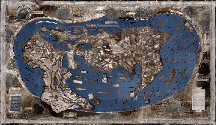
The Martellus map enhanced with multispectral imaging
After months of image processing and analysis, the multispectral images rendered most of the previously illegible text on the map legible. The National Geographic describes some of the legends in an article:
Here are found the Hippopodes: they have a human form but the feet of horses,” reads one previously illegible text over Central Asia. Another describes “monsters similar to humans whose ears are so large that they can cover their whole body.” Many of these fantastical creatures can be traced to texts written by the ancient Greeks
The detail in which the interior of Africa was described geographically was particularly surprising for the researchers. They also discovered that Waldseemüller’s map of the world had borrowed its text liberally from the Martellus map – a practice not uncommon for those days.
Essentially, these findings provide us with enough clues to suspect that when Columbus sailed across the Atlantic, he pictured himself sailing down the coast of Asia as shown on the Martellus map.