
Users of large volumes of geospatial data are currently challenged. With Copernicus, Europe’s flagship Earth Observation programme directed by the European Commission, there has never been more environmental information openly available. The new climate reanalysis product ERA5 from the Copernicus Climate Change Service for example is expected to have a total volume of 5 PB alone. This wealth of information brings new opportunities for detailed global environmental analyses or long-term time series analyses. At the same time, with the verge of cloud services, unprecedented processing capabilities arise. Cloud services may offer data storage, data access and data processing in one place, allowing data users to fully concentrate on the data analysis rather than data download or data preparation.

The new wealth of information, that allows for analyses that were impossible before, brings along new challenges. Challenges arise for data providers and providers of data services. The scope of current data services ranges from traditional download services up to new cloud-based processing platforms, such as the Google Earth Engine or the Copernicus Climate Data Store.
As diverse as the many available data services are, the diverse are the user groups of Big Earth Data. The term Big Earth Data in this context refers to digital information about Earth, including observations, imagery, derived higher-level products, forecasts and analyses produced by computer models. The group of climate data for example contains a wide range of scientists (meteorology, climatology, hydrology, ecology, but also social sciences), decision-makers, resource managers and public health officials, but also start-ups, established companies in the insurance and energy sector. User groups whose knowledge on the data itself and technical expertise vary.
Traditional data download services are not bearable anymore
The fact is: with the current and expected Petabytes of Big Earth Data, traditional download services are not bearable anymore, for data centers and data users alike. Future data services will most likely rely on cloud services. However, there are still many questions how these future data services can look like. For example:
- would users trust a cloud-based service,
- would users like to have data access and processing combined with available processing tools,
- would users pay for cloud-based processing and if yes, how much are they willing to pay,
- how do users interact with the data at the moment and how would they like to interact in the future,
- what processing tools do users use and
- what data formats do they prefer?
A user requirements survey on Big Earth Data aims to better understand the above questions. Users of large volumes of environmental data, e.g. satellite images or meteorological fields, are invited to participate to the survey.
Users of geospatial data in the spotlight – Have your say
The survey aims to find out how users interact with Big Earth Data and what challenges they face due to the increase of data volume. One section deals with future data services and cloud services. It aims to find out how users would like to interact with cloud-based data services and what requirements needs to be fulfilled in order to have the trust of data users.
By participating to the survey, you help to indicate the direction and evolvement of future data services.
The survey is part of a PhD thesis on “Big data technologies for meteorological and climate data” at the University of Marburg, Germany, in collaboration with the data services team of the European Centre for Medium-Range Weather Forecasts (ECMWF). ECMWF is an intergovernmental organisation and both, a research institute and a 24/7 operational service, producing global numerical weather predictions and other data for its member and cooperating states and the broader community. ECMWF runs two out of six Copernicus Services, the Climate Change and Atmosphere Monitoring Service. Both services produce environmental information on climate (e.g. climate reanalysis data or seasonal forecasts) and the atmosphere (e.g. Ozone and parameters to measure air quality, e.g. nitrogen oxides).
Participants can indicate whether they are interested in the results of the survey. The results of the survey will be published next year.
The survey will be open until 30 January 2019. It should not take longer than 10 minutes to fill out.


#Ideas


Next article
Meet Beeline – the startup that is reinventing the compass for the digital age with its connected navigation device

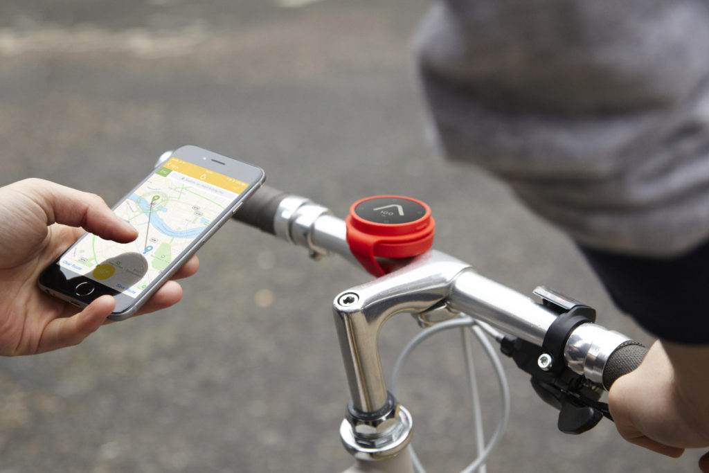
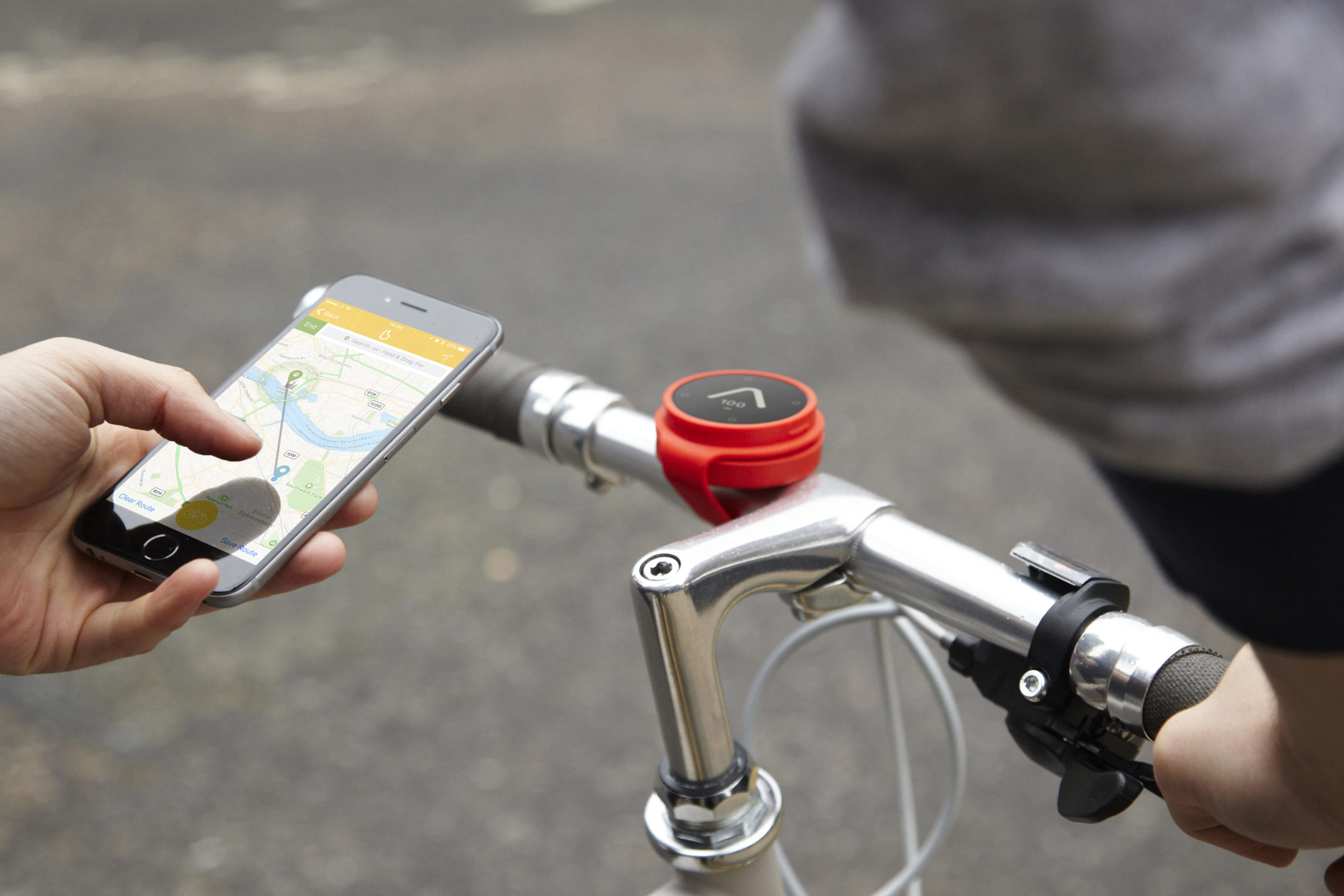
Thanks to GPS/GNSS, we are all habituated to using our smartphones to navigate from A to B. When you are a pedestrian this approach quite well most of the times but imagine riding a bicycle and trying to look at your phone to figure out which direction to go. Yup, it is harder. In a sense, it just takes the joy out of riding a bicycle.
Wouldn’t be great is if we had a device to point us in the direction that we want to go i.e. Jack Sparrow’s compass repurposed for navigating from A to B, if you please! Such a device sounds like a “great idea” but is there a real business case here?
At a time where (successful) hardware startups are hard to come by, Beeline, a London-based startup believes that they have a product that we would all need – a connected navigation device that makes it easier for us to navigate and make journeys fun again. I had the pleasure of chatting with Tom Putnam, the co-founder of Beeline to learn more about their vision, the challenges of running a hardware startup and life in London. Read on!
Q: Tom, thanks for taking the time! Beeline is a hardware company that is reinventing the compass for the digital age! When did you decide that you want to start your own startup and what were the events that lead you to decide to take the plunge into entrepreneurship?
A: I think I’d always had it in the back of my head that I’d like to start something myself. Certainly at least since I started my first job which was interesting but it made it clear I’d much rather be doing something myself. That was a full suit and tie corporate job so it would have been a bit of a plunge to go straight into entrepreneurship. So I took the baby step of working for a well funded Rocket Internet startup in Kenya for a couple of years to learn the ropes first. I was ready at just the same time my good friend Mark was ready – so we jumped together and set up Beeline.
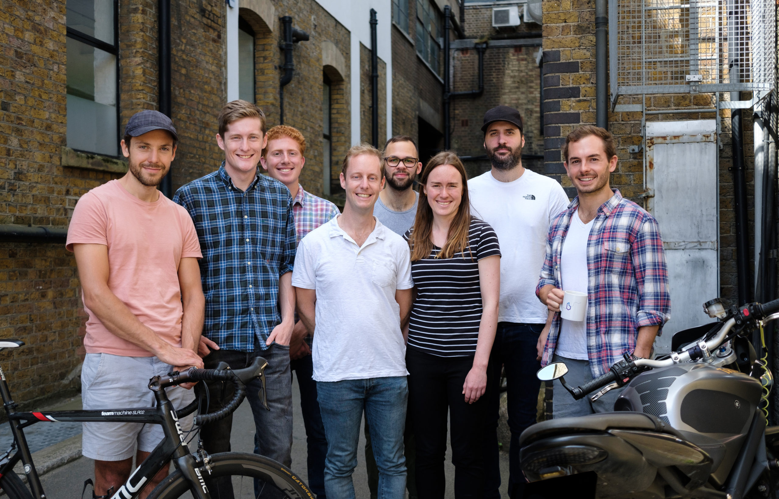
The Beeline Team
Q: Your first product “Beeline for bicycles” is basically a simple, connected hardware that makes it easy for cyclists to get from A to B while enabling them to share their journey with family and friends. Care to convince us why we need a gadget to do this instead of using an app on our smartphones?
A: Too easy! Let’s assume you agree with me that continuously pulling your phone out of your pocket to check is far from ideal. The alternative then is strapping your £/€/$1000 smartphone (and extension of your arm) onto the front of your bike to take on the rattles of potholes, the weather gods and the sticky-fingered thieves of the city. Quite a gauntlet. That’s before we consider how long your phone’s battery will last on full navigation.
Q: The “Compass Mode” on Beeline is just brilliant. It’s definitely one of those things that is so simple yet none of our navigation apps have it (to the best of my knowledge). Were you riding your bicycle with a compass? How did this feature end up on beeline?
A: We arrived at that by starting with the concept of a compass and making it smarter rather than taking a satnav and making it dumber. As experienced cyclists, we felt that a compass was almost enough most of the time and if only if locked on to your destination (rather than north) it would be the perfect tool – hence Beeline (and the original compass mode) was born. Although we’ve now added much more sophisticated routing, this is still my favorite way to ride. It’s so much more explorative. By picking your way through back alleys and opening yourself to serendipity you find that places you thought you knew are full of surprises.
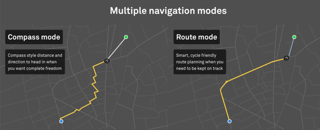
Multiple Navigation Modes on Beeline
Q: Navigation and routing play an important role in your product. You have the “route mode” that gives people a route that is optimal for riding a bike. What’s next? Have you perhaps thought about the safest route, the greenest route, and all the other possibilities?
A: Absolutely. Up to now, we’ve been using Google Maps’ API which leaves a lot to be desired for cycle routing. So we’re building our own routing engine which will allow much more flexibility in how it’s optimized. Allowing people to prioritize, as you say, things like safety, speed, efficiency or maybe even just “niceness” of the route based on the feedback of others.
Q: I can imagine that all the crowdsourced cycling routes is a data scientist’s treasure. Could you perhaps tell us more about your plans there and what is in store for your customers?
A: I can’t share everything, but as you can imagine there’s a whole wealth of insight to be drawn from looking at where people choose to cycle when only loosely guided. For our data scientists it is indeed a treasure trove – not just digging into trends and patterns, but thinking about what does all this mean in terms of decisions humans make. From the users’ point of view, the end result should be cycle routes that simply feel great – without feeling the complexity of all the work that’s going on ‘under the hood’
Q: Beeline uses Google Maps and your routing algorithms. Could you perhaps tell us more about your tech stack? What programming languages you use, etc!
A: Sure, here is a quick overview of our apps and website.
A: They were really excited actually! Hardware is a really hard sell to VCs as they’re looking for billion-dollar exits, fast. There are of course hardware companies which have done this, but as a general rule, they take longer to scale and are less likely to blow up overnight. Friends, family, and Angels, however, aren’t tied to such rules and get excited by real products that solve real problems they feel themselves. So I think for them, this was much more interesting than had we been building some Fintech B2B SaaS platform!
Q: You are based in London – the home of Geovation! Are there many startups like Beeline that are building their own hardware product? How’s the startup scene there in general?
A: And proud! Yes, there’s a pretty good hardware scene here. For example, our industrial design agency partner, Map Project Office, has been involved with at least 5 other London hardware startups in just the last two years. It’s a good community. That said, it’s small enough that it feels like we all know each other which is very different from being a London software startup.
Q: As the founder of a startup that builds its own hardware, you are even more unique than the other companies we’ve interviewed on #TheNextGeo. What’s your advice to budding geo-entrepreneurs wanting to build their own product?
A: Tough one. I think my biggest bit of advice would be to keep on sense checking as you go. Building hardware takes a lot of money and a lot of time – your time. So you want to be sure you’re building something people want and not let yourself be deluded by your own love of what your making (assuming you need customers!) Kickstarter is great for that as it validates the demand. Even before that we *tried* to be unemotional about it. For example, back in 2015 we tested our first prototype with 10 people and said that if the majority of them didn’t like it we’d can the whole thing. Luckily Beeline is still here today though!
The Next Geo is supported by Geovation:
 Location is everywhere, and our mission is to expand its use in the UK’s innovation community. So we’re here to help you along your journey to success. Get on board and let’s start with your idea…
Learn more about Geovation and how they can help turn your idea into reality at geovation.uk
About The Next Geo
The Next Geo is all about discovering the people and companies that are changing the geospatial industry – unearthing their stories, discovering their products, understanding their business models and celebrating their success! You can read more about the series and the vision behind it here.
We know it takes a village, and so we are thrilled to have your feedback, suggestions, and any leads you think should be featured on The Next Geo! Share with us, and we’ll share it with the world! You can reach us at muthu@geoawesomeness.com or via social media 🙂