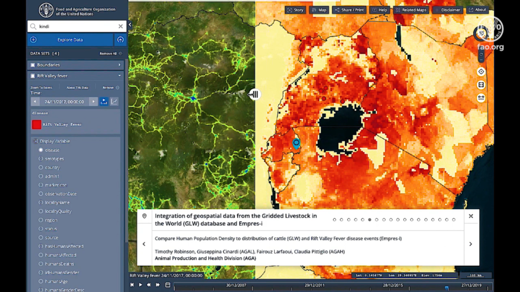


Snapshot from FAO’s geospatial platform
The Food and Agriculture Organization of the United Nations (FAO) has launched a new geospatial portal that would help to build more resilient food systems post COVID-19. Called Hand-in-Hand, the geospatial platform contains over 1 million geospatial layers and thousands of statistics with 4,000 metadata records for more than 10 food and agriculture-related domains.
FAO experts from multiple domains, right from Animal Health to Trade and Markets, have worked together to integrate data on soil, land, water, climate, fisheries, livestock, crops, forestry, trade, social, economics, etc., onto the platform.
The data has been sourced not only from FAO, but also the agency’s partners and other public data providers across the UN, NGOs, private sector, and space agencies. The portal also contains FAOSTAT data on food and agriculture for over 245 countries and territories from 1961 to the most recent years.
Anyone can access this platform to analyze trends and create interactive maps that would foster data-driven and evidence-backed decision-making in food and agriculture. Use cases could include:
- Analyzing precipitation trends
- Keeping tabs on agricultural water productivity and monitoring agricultural systems at risk due to human pressure on land and water
- Comparing human population density to the distribution of livestock species
- Ascertaining aquatic species distribution
- Analyzing information from national forest monitoring systems that understand the distribution of forest resources with other geospatial data such as the road network
Stressing that the portal will help to identify real-time gaps and opportunities in agriculture, FAO Director-General, QU Dongyu, says, “Geospatial technologies and agricultural data represent an opportunity to find new ways of reducing hunger and poverty through more accessible and integrated data-driven solutions.”
FAO plans to add new datasets and country- and domain-specific case studies also to the platform in the near future. This, FAO hopes, would help to encourage innovation, finance and investment, and institutional reform in food and agriculture through tailored policy intervention.
As FAO’s Chief Economist, Maximo Torero, sums up, “The geospatial platform will allow us to design more targeted agricultural interventions and investment plans through a territorial approach – an approach that fosters equality, inclusion and sustainable food and nutrition security.”
To explore the Hand-in-Hand Geospatial Platform, go here.

#Featured


Next article
How Google is using submarine cables as earthquake, tsunami warning systems
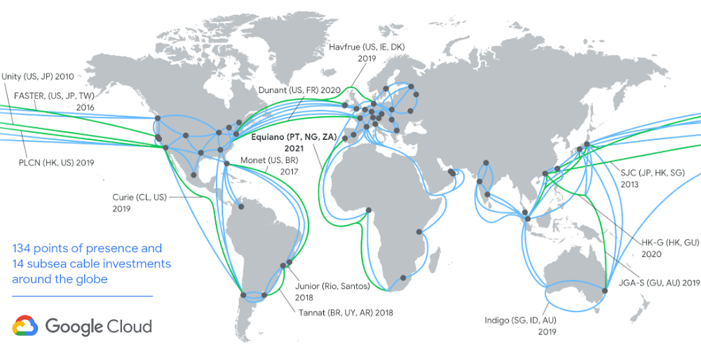
Google’s 15th subsea cable investment is rumored to be a $400 million one, connecting Italy to India. It’s called Blue-Raman
Google owns the largest submarine cable network in the world. Undersea cables make it possible for us to use the Internet to share, search, send, and receive information at the speed of light. And now, these fiber optic assets may just prove useful to improve earthquake and tsunami warning systems around the globe.
Scientists have been toying with the idea of leveraging subsea infrastructure to detect seismic data since 2018. These approaches have required special sensing fiber and additional equipment, and have proven effective over distances of up to 100 km.
Google, meanwhile, has developed a technique that could work over tens of thousands of kilometers – using nothing but the world’s existing fiber optic systems to detect disturbances on the seafloor.
“One of the properties of light that is tracked as part of the optical transmission is the state of polarization (SOP),” Google explains in a blog post. The SOP changes in response to mechanical disturbances along the cable.
In late 2019, Google began to track these disturbances, looking specifically for spectral signatures of seismic activity. The first earthquake it detected was on January 28, 2020. A magnitude 7.7 earthquake was reported off of Jamaica – 1,500 km away from the closest point of one of Google’s cables! In further detections, Google’s researchers were able to validate their observations with established seismic monitoring stations.
An analysis of Google’s data reveals that not only can we detect earthquakes emanating from tectonic plates, but we can also detect pressure changes in the ocean itself, which could help predict tsunamis.
If Google finds a way to convert its demonstrations into a fully-working system, it could prove monumental for tsunami detection. As Google points out, most tsunami detection equipment today is either onshore or scattered throughout the ocean. The former doesn’t give coastal communities enough time to evacuate and the latter is limited by the speed of the traveling wave — a maximum of 800 km/hr for a deep-sea wave. On the other hand, when a cable runs near the earthquake epicenter, a tsunami warning system that transmits data at the speed of light could communicate a warning to potentially affected communities in milliseconds.
Google is now looking to explore advanced computing and machine learning to provide seismic research communities with a source of complementary information to enable early warnings for earthquakes and tsunamis.