
The most recent Esri DevSummit took place from March 7-10 in Palm Springs. The DevSummit in general is geared at web developers who work with Esri technology and offers an overview of the most recent Esri technology. For those who couldn´t visit the event, Esri published a number of videos from the plenary session on its own website, while a playlist of 163 videos can be found on YouTube. Here are five great videos that caught my interest:
1. Getting Data Science with R and ArcGIS
Data science is a hot topic. This video discusses Esri´s involvement in the R community and support for R in the ArcGIS platform. If you want to know more about what R is and how it can enhance geospatial workflows, this is a great resource. It also compares the SciPy stack with R, features various demos on how to get started with the ArcGIS-R bridge and resources for writing custom R script tools.
2. Scientific Programming with the SciPy Stack
More data science, this time covering the Python programming language. A video dedicated exclusively to the SciPy stack and how it extends the ArcGIS platform. Features demos on NumPy, pandas, matplotlib, SymPy and SciPy, which is a separate package within the SciPy stack as a whole. After watching this video you will know what each package does and where to look for it. If you´re new to this stack, you´ll find a lot of resources on how to get started at the end of the video.
3. Git/GitHub for Geographers
Geographers and GIS analysts looking for an entry point to the world of Github don´t need to look any further as this video explains all about cloning, forking, branching, version control and much more.
4. JavaScript for Geographers
Another great introductory session for geographers, this time on JavaScript. Starting to learn JavaScript in 2017 can be intimidating as there are many tools out there to use. This video shows how to start from zero and get up to speed. Covers the language fundamentals, how build web apps with JS and the ArcGIS JavaScript API. Also available is a video called CSS for Geographers.
5. Choosing a Javascript Framework in 2017
Maybe not for beginners, but a must for intermediate and advanced JavaScript developers, this session covers the most popular JavaScript frameworks available at the moment. Topics covered are Ember, Angular2, the Dojo toolkit, React, ES6, Typescript and more. Presenter Dave Bouwman discusses the JS frameworks that are used within Esri and the options JS developers have for building their own GIS web apps in terms of frameworks, libraries and ecosystems.

#GeoDev
Next article
USGS “Water On-the-Go” App Helps Keep Texans Safe with Current Stream Conditions

For more than 100 years, the US Geological Survey (USGS) has monitored flow in selected streams and rivers across Texas. The information collected at USGS monitoring stations is routinely used for water supply and management, monitoring floods and droughts, bridge and road design, determination of flood risk, and for many recreational activities.
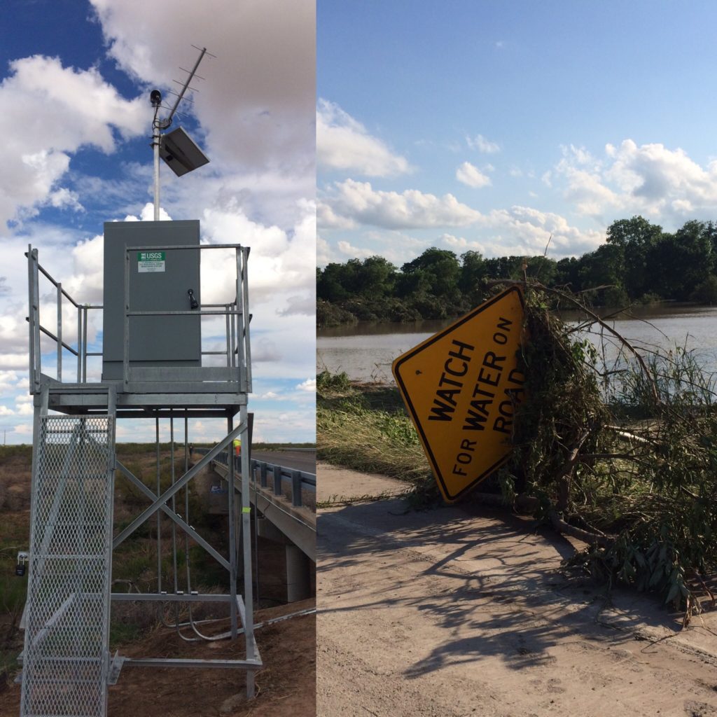
USGS monitoring station (left). Blanco River flood near Martindale, TX on Memorial Day 2015 (Right)
Following a period of prolonged drought, the State of Texas experienced a series of devastating floods in 2015 and 2016 that broke the 5-year drought and led to a new era of innovative web development to distribute real-time water information to the public. In response to those events, the USGS Texas Water Science Center developed a new mobile web app called “Water On-the-Go” that gives people easy access to current water conditions across Texas direct to their mobile device.
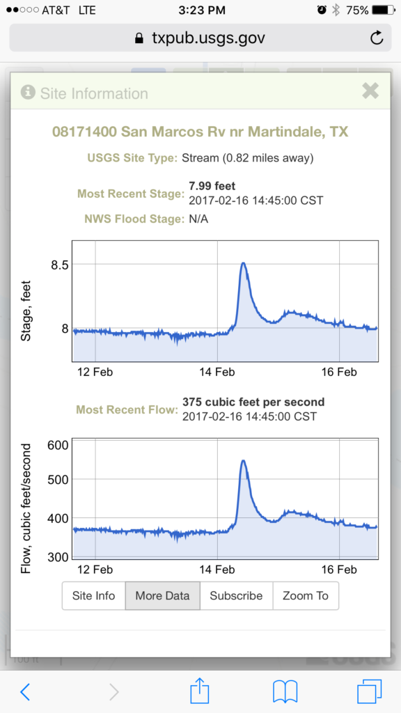
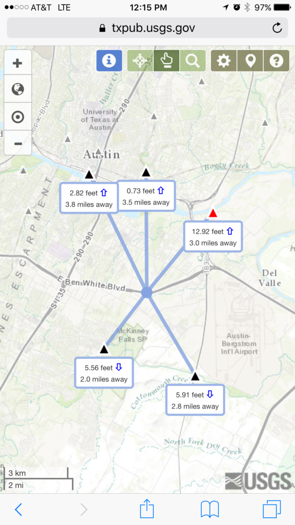
The new mobile-friendly website allows users to quickly locate nearby USGS monitoring stations and access up-to-date streamflow, stream height, rainfall or lake level information in a few easy clicks. The application offers three ways to find streamflow or other data, which include; using your mobile device’s on-board GPS, clicking on an area of interest, or by searching for a physical location by name. Results show what is happening in streams and lakes near you and how quickly conditions are changing around you!
Be safe. Be smart. #BeWaterAware. Go to https://txpub.usgs.gov/water-onthego and bookmark the link today!