
A few years a go, Bill Davenhall, who was ESRI’s Global Marketing Manager for Health and Human Services Solution on Geomedicine at that time gave an insightful TED talk “Your health depends on where you live“.
Since the TED talk back in 2010, National agencies across the world have understood the importance of having location information tagged together with health records and Geomedicine as grown in importance ( Geomedicine: Can Geographic Information keep you healthy?).
When you think about it, having your place history together with your health record makes a lot of sense, it helps identify potential health issues due to environmental reasons and lets you be aware of your choices and their impact on your health.
But in the era of Internet of Things and Wearable tech, is place history the only piece of geotagged information that we can use?
Some of the most interesting use cases for Internet of Things has been in environmental monitoring, there are many applications that utilize crowd sourcing and IoTs to get data on air pollution, noise levels and even monitor light pollution. These apps typically use a map to visualize the information, helping create awareness about the impact environment has on human health. (Read: HabitatMap & AirCasting: Internet of Things, Maps & Environmental Monitoring).
Most fitness bands and Smartwatches have an 3-D accelerometer and a heart rate sensor. Some of them even have a GPS or synchronize with the smartphone to get GPS data. All this data is then used to let you know the route you used to walk/run/cycle, the calories you burned, your resting heart rate, etc. Similar information from smartphones have already helped map the places where people choose to run, walk or bike (1.5 Million Walks, Runs, and Bike Rides from RunKeeper mapped on Mapbox).
Combine the Internet of Things environmental monitoring together with these Wearable Tech/Smartphone fitness data and we already have two layers that can be used to inform people about whether, it is a good idea to run in that region, at any time of the day. Simple, basic GIS that can help people make healthier choices. Maybe urban planners can utilize this data to see if people really like to run along the jogging paths they created, etc. Add algorithms that finds the most beautiful route between A and B to the mix and already we have a better interest in getting out there on the bike. Most certainly there are a million better ideas out there that already look to utilize Internet of Things and Wearable tech for Geomedicine.
In some sense, the whole idea might sound like a complication of a simple problem – how to be healthy? For every factor that is in our control (being active, eating healthy, etc.) , there is another that isn’t really in our control (environmental pollution, etc) . If a complex computer application that crunches lots of spatial data and mines patterns to help lead healthier lives, maybe it’s not useless complication.
We already know, Geographic information can keep us healthy, many studies have help solve that question, the next question that needs to be explored is “How best to utilize Wearable Tech and Internet of Things in Geomedicine?”
Geomedicine is an idea whose time has come. – Bill Davenhall


#Business


Next article
If you’re reading this blog, you’re most likely a serious geo-geek. You are no stranger to GPS tech and your heart beats faster when you see a cool map. But being in a spatial state of mind means also to suffer… It hurts when you see a great idea, which is wasting its potential by not fully utilising the context of location.
Let’s take as an example Twitter. It’s a brilliant service which taught 1 billion of its users that you can communicate your thoughts using just 140 signs. The location-compotent is there but it doesn’t bring any value added neither to users nor to Twitter itself.
TWITTER BUT “GEO”
Have you ever imagined how would the Twitter look like if it had been designed by a geo-geek? I have and I think that the best answer to this question is a new Android app called Local Snaps. The app allows you to connect your experiences and ideas with your physical location and display it on a map. It is something that you’ve always wanted to see on Twitter but it was never there.
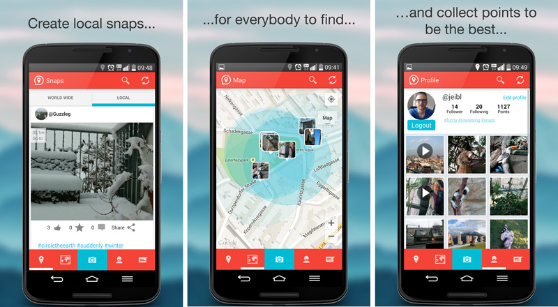
WHAT IS IT ALL ABOUT?
The idea for the app is simple. It allows you to share with the world your “Snaps” which are moments captured with photos or videos. The photo/video is than displayed on the map or in the news feed. Similarly to Twitter when you publish something the whole world can see it but on the other hand you can also view “Snaps” of everyone else on Earth. Every photo gets you points. When someone views, likes and comments on your photo it gets you additional points. So basically the app takes the best features of Twitter and Foursquare’s Swarm (which introduced the concept of gamefication in location-based apps) and connects them together.
FAST AND SNAPPY
The app is really well designed. User interface is simple, intuitive and not overloaded with plenty of unnecessary features. I must say that I’m really surprised how fast this thing works. Newly developed apps, especially those which process a lot of photos or videos tend to get slow or crush. I’ve been using Local Snaps for couple of days now and I haven’t seen any of these issues.
THE RISE OF LOCATION-BASED GIANT?
Is there a big future in front of Local Snaps? Will it be the next Twitter or at least Foursquare? I hope so. It’s a million dollar idea followed by a great app.
But be aware!!! The app is highly addictive.