
 Telenav acquires OpenStreetMap leader Skobbler, the Berlin based startup and developers of leading location-aware apps and GeoInfo games based on the open source OpenStreetMap (OSM) in a deal valued at $24 million. Evidently Telenav is seeking to consolidate its position in the OSM domain.
In addition, this will also benefit Telenav’s Scout application that provides location based “Things to do” information in United States. This move could see Scout being available for Germany and other countries in Europe in the future.
What does this mean for the OpenStreetMap community?
OpenStreetMap is the wikipedia of maps and is an open source competitor to Google Maps. Even though OSM data is being for commercial purposes like Skobbler’s Apps, the data is still free for use by anyone which in contrast to Google maps where one can only add information but not use it for commercial purposes. FourSquare and Wikipedia are notable organization that use OSM data. This acquisition will help Telenav position itself as a competitor to Google Maps and related applications. With OSM data and the most leading applications at one place, Telenav could emerge as serious competitor to Google’s Location information solutions. Hopefully we will see more applications that utilize OSM data in the future. This move might also energize more startups and companies to use OSM data, now that the tech giants are taking note of an open source model.
It is going to be interesting to see if the benefits of an Open Source model is going to change the dynamics of the navigation and location-information market.
Source: Wall Street Journal


#Business


Next article


Last weekend, I was walking around the city center and by accident, I crossed a little boy (8 years old) who had lost his way and looking for somebody to direct him home. That was a very interesting accident; I would call it a serendipity. I speak extremely poor German and the boy doesn’t speak English. Imagine, how horrible situation, it could be. Anyway I started trying figure out his crisis. It took time but I was able to understand “verloren” (means lost) and “Adresse” (means address) and the address was “dot dot…”. Of course, I did not know that address so I took out my cell phone, googled the address and started the navigation. After 22 min of walking, I was able to put the boy home. Those 22 min was some of the most surprising min i ever had.

When I took out my cell phone to find his address on map that little boy opened the door of continuous surprises. He spoke up, “navi” (navigation). He knew what it is and predicted what I am going to do with my cell phone. Which means he was not only aware of navigation tools but also realized what it can do. The boy also knew the word “location” (in German maybe its “Lage”), though he did not have any orientation of English. He was Also familiar with the word “Karte” (map) and “Richtung” (direction). That was awesome because I talked with him about half an hour using only geospatial terminologies. In that half an hour I got a complete new realization about the awareness of “spatial” awsomeness among kids. Either I met a very smart kid or I am not aware about the awareness level of geospatial technologies among kids.
I dig deeper; why that boy knew all those? how he realized geospatial technologies? is somebody teaching him those specific things? is it the academic education?
I shared my incredible experience with few parents, teachers, adults & students and asked what they think about the reasons behind those “Spatial-Kids”. From those discussion, I guess, it’s not the academic education what making kids, spatial-kids but the era of “smart phone” and “navigation” system. A kid and a car, with a moving map display and a smart lady telling him direction and destination; the navigation system changed the scenario dramatically. Then again, a significant number of kids start using smart phone from the age 5 or around (… of course parent’s cell phone for games); have a orientation of smart devices. Besides, technology advanced parents also introducing the kids with google earth and kids just love it, flying over world. and finally the map knowledge from school. Those are the things, what making a kid Spatial. That’s why a 8-years old kid know what a map, location, direction and navigation is and what it can do; finding a lost boy home.
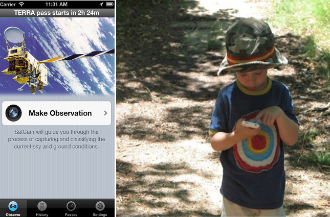
OK, now we know kids are already Spatial and they love games. What we can do to use Kid’s knowledge in GIScience? The answer is we can utilize “kids to validate satellite images”. sounds scary? it’s not scary rather simple. there are aps like “SatCam”; which lets user capture (i.e., take picture) observations of sky and ground conditions at the same time that an Earth observation satellite is overhead by alerting (i.e., alert intervals of 5 and 2 minutes) the user in advance. the current status of the app is not suitable for kids but if we can reshape it with only two simple components: 1) satellite overhead alert and 2) take pictures. Kids hear the alert alarm in his/her mama’s cell phone (…and which automatically launce the application asking for take a picture) and s/he take a picture. that picture will be automatically posted with coordinates and automatically the app will shut down. so no functionality which needs to take care of and kids easily can do that. Now, Don’t you think, it’s possible, to use kids to validate satellite images?
Few more items, I would love to mention:
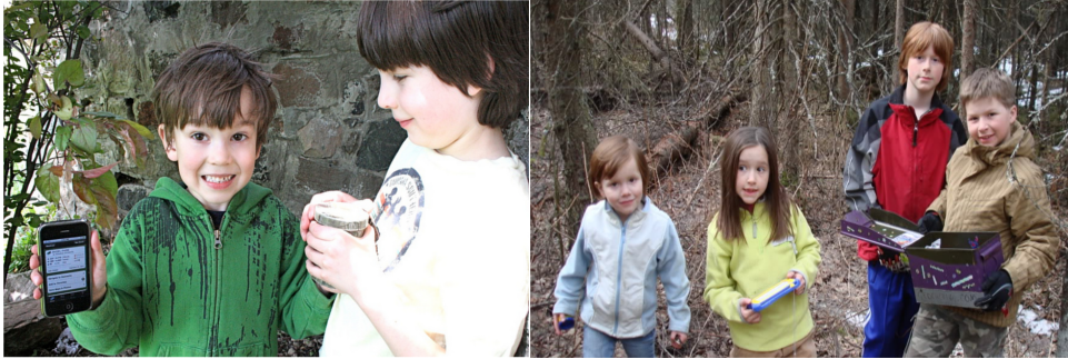
a) Kids could be the best share of crowd sourcing because they love games and now a days, gamificnation and crowd sourcing or citizen science sleeps together. what we need is simple applications. if it is so, we can use kids for satellite data validation. besides “kids and geocashing” is already a stable lesson.
b) Now it’s the perfect time to add some ground level geospatial technology education in the academic syllabus because they are the future and our future is geospatial technologies.
c) I believe crowd source applications, (…with proper usability test which provides the opportunity to utilize spatial kids) will make most of the crowd sourcing application successful.