
International migration is a hot topic and a global phenomenon that is growing in scope, complexity and impact. It can be a positive force for development when supported by the right set of policies but performed unreasonably migration can cause short-term or long-term issue swhich is the case in couple of European countries.
Understanding global mobility patterns and its impact on countries is very difficult without a great map… but don’t have to worry about that any more as Esri has launched a new cool tool where you can visualise global migration country by country. The project is called Global Migration Data and it shows estimates of the number of international migrants by destination and origin. The data comes from the UN Department of Economic & Social Affairs for the years 1990, 2000, 2010 and 2013.
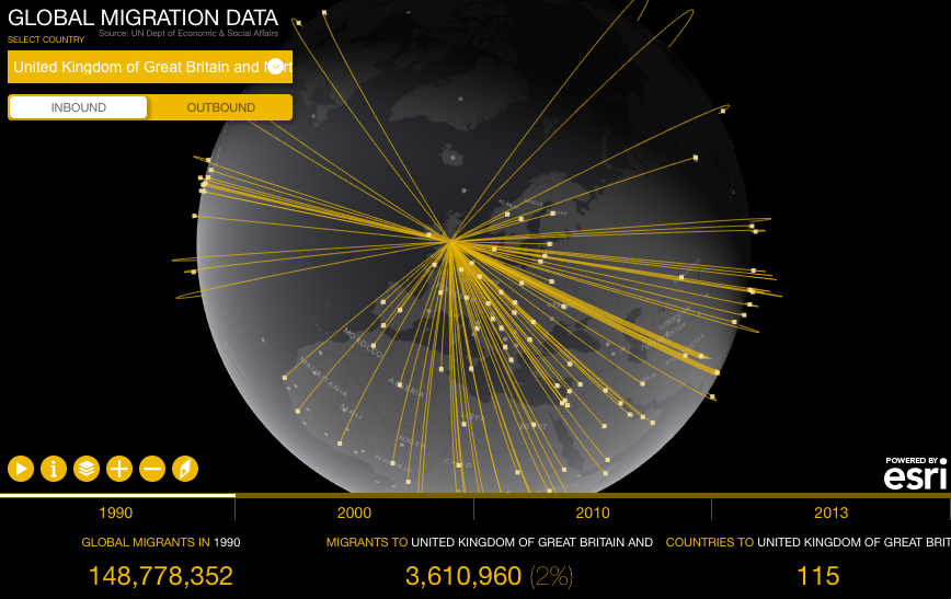
The map is very easy to use. On the top left menu you can select a country as well as its incoming or out coming migration. Below the map you’ll find a timeline where you can select years you wish to visualize on the globe. On the bottom of the website you’ll find the total number of migrants globally, per selected country as well as the number of countries migrants are from or the number of countries migrants moved to.
Cool project and a nice show case of what can be done using Esri web tools.

#Ideas


Next article

A few weeks ago, the acquisition of HERE by the consortium of BMW, Daimler and Audi was approved by the German Antitrust authority and today (7th Dec 2015) marks the official beginning of a new chapter in the history of HERE (Related: Starting today, it’s a new world for HERE…).
So what next?
In the blog post announcing the new chapter for HERE, a few key areas were highlighted – smarter urban mobility, evolution of the car, a new era of transportation and better management of assets.
Cars as real-time sensors
HERE has been working on the Autonomous Driving project for a while now and the renewed focus on using data from cars is going to serve the company better in the long run (Related: Interview with HERE about their Autonomous Driving project).
In a related Associated Press report, the consortium (BMW, Daimler and Audi) are looking at turning their cars into real-time sensors that will provide anonymous data to the HERE map service (Read more: German automakers want real-time car data for maps app).
Tesla has already been using their cars as real-time sensors and the recent AutoPilot feature has only showcased the potential of using connected cars for updating and maintaining HD map, so it’s only natural that the consortium is looking at ways to maximize the existing potential of HERE to further their autonomous driving projects.
Best wishes @HERE
4 of the top ten “Most Innovative Companies” listed by the Boston Consulting Group were car manufacturers, signalling the importance connected cars and related tech have in our lives. This is great news for HERE and for their future.
Here’s wishing HERE the best on their new chapter 😉 Keep the awesomeness going!
https://www.youtube.com/watch?v=jM2qdXYSlyg&feature=youtu.be
Source: HERE 360, Associated Press