
European Space Agency has decided that November 12th, 2014 will be the day when the Rosetta Mission lands “Philae” the lander on the surface of the comet Churyumov-Gerasimenko or simply 67P (Remember Rosetta). If all goes well, November 12th, 2014 will be the first time in the history of mankind, a probe lands on a Comet.
Science fiction was there first though, remember the book by Greg Bear called “EON“? It sure does feel like Science fiction – Chasing Comets and landing on a probe on it! But all this for real and The Rosetta Mission is already the first mission to rendezvous with a comet, the first to follow a comet around the Sun and sent back pictures of it. It took over 10 years and 4 billion miles for Rosetta to get to Comet 67P. It had to hibernate for 957 days to accomplish all this.
The lander, Philae is equipped with a camera and will take a 360-degree panorama of the comet surface. Besides measuring the gas pressure and dust distribution at the landing site. It will also drill beneath the surface of the comet and analyze the material. Comets are considered as “pristine planetary building blocks” and all this investigations will hopefully throw more light into the history of the universe and the role that comets played in shaping life on our planet.
So where is Philae going to land?
ESA has decided to land Philae on Site J after a lot of consideration. The site has been chosen as it is relatively flat with far lesser cliffs in the terrain. But the landing is going to be anything but easy. Remember, this is a comet that is constantly rotating as well. The Comet completes a full rotation in about 12.4 hours. So when Philae is actually descending down to the surface, the landing site would be in the opposite side of the Comet! Well, this could be the most complicated landing in the history of our space programs.
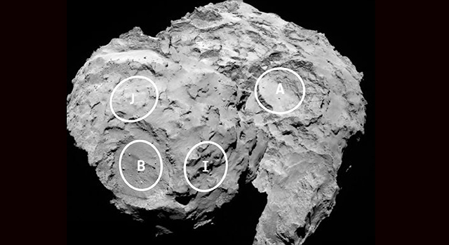
Image Credit: ESA/Rosetta/MPS for OSIRIS Team MPS/UPD/LAM/IAA/SSO/INTA/UPM/DASP/IDA
At 08:35 GMT, the landing sequence will begin and Rosetta will release the lander , Philae at an altitude of 20 kilometers above the comet. Philae is expected to arrive at the surface of the comet 67P at 15:35 GMT i.e. 7 hours later. During the 7 hour descent, Philae’s ROLIS camera is set to take a series of photos of the comet. If you are interested in learning more about the site selection, read this article by NASA.
Here’s a nice video by ESA regarding the descent and science on the surface of the comet.
This is by far, the most exciting space mission in recent years. In my opinion, this is right up there with NASA’s Apollo Missions! Landing a probe on a Comet after 10 years and 4 Billion miles. Who would have thought of that! A new era in Space exploration is well underway! Rosetta Mission all geared up for Landing on the comet on 08.35 GMT, November 12th, 2014! Are you? 🙂
Reference: BBC News & UniverseToday


#


Next article

The miracle of flight 370 of Malaysia Airlines has concerned affected families, airlines, forensic officers and authorities during spring and even summer of this year. In our “big-brother-is-watching-you” environment it was hard to believe that a plane could just get lost without being tracked by one of the satellites in space that observe our planet every day. The revealing truth is that the vast surfaces of the Earth cannot be reached or covered by signals and particularly remote places as oceans that are of less interest to our human activities remain blind corners. Since the Second World War, radar has been the primary method to monitor aircraft movements beyond the line of sight. But flight tracking technology isn’t as comprehensive as many might have thought, because current radar doesn’t have global coverage and if a transponder fails (as it was the case for the Malaysian flight) there is little that can be done.
ADS-B Technology
Automatic Dependent Surveillance – Broadcast (ADS–B) is a very recent cooperative surveillance technology, in which an aircraft determines its position via satellite navigation and periodically broadcasts it enabling it to be tracked. The information can be received by air traffic control ground stations as a replacement for secondary radar. It can also be received by other aircraft to provide situational awareness and allow self separation. ADS-B has become a widely accepted alternative for air traffic surveillance, providing critical information to controllers and pilots. The technology is mandatory in parts of the Australian airspace and will be mandatory for commercial aircrafts in Europe until 2018 and the USA until 2020. Although ADS-B is promising to improve plain tracking it is limited to land-based areas leaving considerable gaps over the ocean surfaces.
Aireone Alert worldwide available
Since some time, the plane tracking system “Aireone Alert” has been under development as an extension of ADS-B technology in combination with a new and already planned constellation of low orbiting telecommunication satellites. Aireone is anticipated to be fully operational in 2017. It will make available a global emergency tracking capability that will allow authorized agencies to request the location and last flight track of any ADS-B equipped aircraft that has lost communications with controllers, including over the oceans, poles and remote airspace. This service will be provided to authorized organizations as a public service, free of charge.
How does Aireone Alert work?
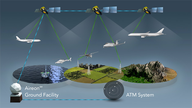
The service is going to use the already planned network of 66 low orbiting telecommunications satellites – called the Iridium NEXT satellite constellation – as ADS-B payload hosts retransmitting signals from ADS-B equipped aircrafts to air traffic controllers through newly installed Aireon Ground Facilities. Due to the wide spread constellation of satellites the service will be capable to track any ADS-B equipped aircraft worldwide including oceanic, polar desert and mountainous regions at real-time visibility. The aircraft tracking at real-time will also offer more flexibility to avoid weather, deviate from filed routes, optimize altitudes in trail and file more direct routes over the ocean. Full surveillance over oceanic and remote airspace will bring more efficient use of airspace, substantial fuel savings, fewer delays and will significantly enhance safety over large parts of the world. Already, Air Traffic Control Providers have committed to to deploying a ground-based ADS-B architecture that uses GPS satellite signals to give air traffic controllers and pilots an accurate, real-time display of air traffic. The use of ADS-B equipment in commercial aircrafts will be mandatory in Europe and the USA by 2018 and 2010, by 2018 Aireon will gradually change the way traffic crosses the North Atlantic through the implementation of oceanic surveillance.
Hopefully an inexplicable occurrence as the disappearance of an aircraft seen this spring will not happen again. Preparing this post, I was particularly impressed by the constellation of 66 low orbiting telecommunication satellites that will host the ADS-B technology regarding the interaction and coordination of the attuned orbits. Also, I thought that telecommunication satellites are only geostationary. Therefore, catch some information about the Iridium satellite constellation at the bottom.
Iridium satellites
The Iridium satellites consist of a large group of telecommunication satellites providing voice and data coverage to satellite phones, pagers and integrated transceivers over Earth’s entire surface. The name derives from the Company Iridium Communications Inc. Even the actual constellation comprises 66 satellites that orbit at a distance of 781km around the Earth. Spare satellites are held in a spare orbit and are boosted into the correct altitude and put into service in case a satellite failes. The over-the-poles orbital design guarantees complete coverage even at very high latitudes around the poles.
The Iridium NEXT satellite constellation is a planned second-generation network of again 66 telecommunication satellites. Beside an enhanced data storage and improved bandwidth the NEXT generation satellites will incorporate data transmission and provide data link to other satellites in space enabling command and control of other space assets regardless of the position of ground stations and gateways. At the moment, satellites communicate with neighboring satellites via Ka band inter-satellite links, the satellites of NEXT generation will communicate at L-band data speeds of up to 1.5 Mbit/s and high-speed Ka-Band service of up to 8 Mbit/s. The Iridium NEXT-generation satellites will also incorporate an additional payload for Aireon tracking System making the Aireon Flight Tracking System possible.
The launch of the satellites will begin in 2015 and be finished in 2017, when the entire new constellation will be fully operational.