
One of the biggest advantages Google maps has over its competition is the accuracy of its real-time traffic information and it didn’t really come as a surprise when they acquired the Israeli startup Waze for around $1 Billion. Traffic data is incredibly valuable and is a critical input for any transportation based analysis/application.
OpenTraffic: A free, global traffic speed data set linked to OpenStreetMap built with open source software

OpenTraffic
Although one would expect traffic data i.e. current and average traffic speeds, etc to be openly available at least in some cases, it is actually quite hard to get this information. Conveyal, in colloboration with World Bank, Mapzen and Mapbox has announced the launch of OpenTraffic to process and aggregate a global, freely available traffic speed data linked to OpenStreetMap.

OpenTraffic: Process map (Copyright: OpenTraffic.io)
The project is still in the pilot phase and the official launch would be sometime later this summer with historic and real-time traffic data in cities around the globe. You can contact them via mail if you are interested in using or contributing to the project at this email address. OpenStreetMap is an amazing project. It is perhaps one of the biggest success stories that showcases the power of Crowd sourcing and Volunteered Geographic Information (VGI). OSM recently added A to B routing on its main webpage, although third-party applications have had this feature for years now. The additional of OpenTraffic dataset to OpenStreetMap is a great idea! It is definitely going to help strengthen the OSM community and applications like Skobbler that rely on OSM data.
Here’s the link to the project.
Source: Conveyal blog


#Business


Next article


Garmin is well-known for making rugged and reliable GPS equipment for aviation and sailing. It is also one of the pioneers in the running watch industry. The strategy of Garmin seems to be simple: find a niche, build a high quality GPS-enabled solution and dominate the whole market segment.
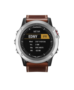 This time Garmin announced a new smart, GPS watch dedicated to pilots. D2 Bravo is a second-generation aviator watch that combines really cool design and practical functionality. And it looks really good. It features a sapphire lens, a steel bezel and glass fiber reinforced housing. It’s all attached to a brown leather band. I must say that it’s one of the best looking GPS watches out there, one of few which I could wear everyday.
It is also packed with features. First of all it has a high-resolution color display and a battery which will last 20h in a GPS mode and 6 six weeks in a watch mode. It’s has a GPS, altimeter, compass with a HSI (horizontal situation indicator) and moving map display. It has some cool features like navigating to the nearest airport, and complete worldwide aviation navigation database. Moreover it can act as a remote control for Garmin’s action cams.
Of course it all comes at a cost. $699 – is quite a lot but frankly speaking it seems that it’s worth the price.
Let us know when you test it.