


Alastair Graham
“The remote sensing community has spent several decades asking for more data. To say now we have too much data would be really churlish,” Alastair Graham quips on a recent episode of The MapScaping Podcast. “I firmly believe we need more open data, not just from government agencies but also from commercial enterprises.”
Alastair, an independent spatial and environmental consultant with more than 20 years of experience in the GIS industry, was pointing to how we should be looking at better management of open geospatial data. This, he believes, can be achieved by using a more standardized approach to data management and collaborating closely with machine learning and artificial intelligence experts. The following open-source projects could help us get there in the near future, Alastair says.
1. SpatioTemporal Asset Catalog (STAC)
 The STAC specification provides a common language to describe a range of geospatial information, so it can more easily be indexed and discovered. A ‘spatiotemporal asset’ is any file that represents information about the earth captured in a certain space and time. The goal is for all providers of spatiotemporal assets (Imagery, SAR, Point Clouds, Data Cubes, Full Motion Video, etc.) to expose their data as SpatioTemporal Asset Catalogs (STAC), so that new code doesn’t need to be written whenever a new data set or API is released.
2. openEO
![]() openEO develops an open API to connect R, Python, JavaScript, and other clients to big Earth observation cloud back-ends in a simple and unified way. With such an API, each client can work with every back-end, and it becomes possible to compare back-ends in terms of capacity, cost, and results (validation, reproducibility).
openEO develops an open API to connect R, Python, JavaScript, and other clients to big Earth observation cloud back-ends in a simple and unified way. With such an API, each client can work with every back-end, and it becomes possible to compare back-ends in terms of capacity, cost, and results (validation, reproducibility).
3. Raster Vision
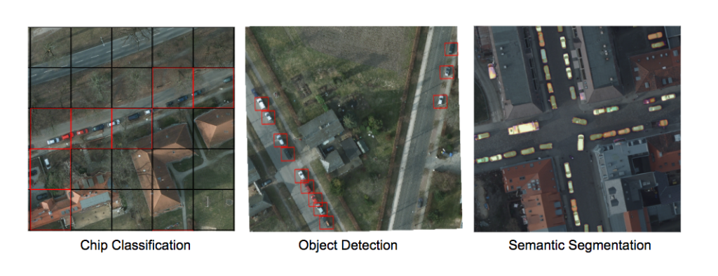
Courtesy: Raster Vision
Raster Vision is an open source framework for deep learning on satellite and aerial imagery. Python developers building computer vision models on satellite, aerial, and other large imagery sets (including oblique drone imagery) can leverage Raster Vision’s built-in support for chip classification, object detection, and semantic segmentation using PyTorch and Tensorflow.
“There’s tons of data in a single image, especially if it is a multi-band image,” Alastair says. “People would usually use that image or a series of images to look at one single thing. I’m still waiting for an application that would take high-resolution satellite or aerial imagery and pull all the information out from the many different thematic areas – right from tree cover rooftop area collection to the number of lights on a street.”
Alastair is convinced that the EO industry would become unstoppable if humans and machines find a complementary working model, i.e., humans feed machines with better training data and machines help humans to extract better insights faster from the troves of open data. “Whatever mistakes the remote sensing community may have made in last few decades must not get repeated just because machine learning experts come from a different domain or view things from a different perspective,” Alastair stresses.
Listen to the full podcast here:

#GeoDev
Next article

Locale is building a location analytics product for city and business teams who want to analyze and optimize their ground operations. Think of it like Google Analytics using location data for any company with moving things. The product converts raw location data into actionable insights to help companies make very precise data-driven decisions.
Listen to Aditi Siha talk about how to manage supply-demand gaps by combining marketing, order transactions and supply availability data.
Sign-up to the Geoawesomeness newsletter to stay informed about all upcoming events and more awesomeness from the geospatial industry.