
Angela Merkel, Hillary Clinton, Melinda Gates? According this interesting article in National Geographic there is one woman who is and has been for a long time more powerful, than this trio… Virgin Mary – the mother of Jesus.
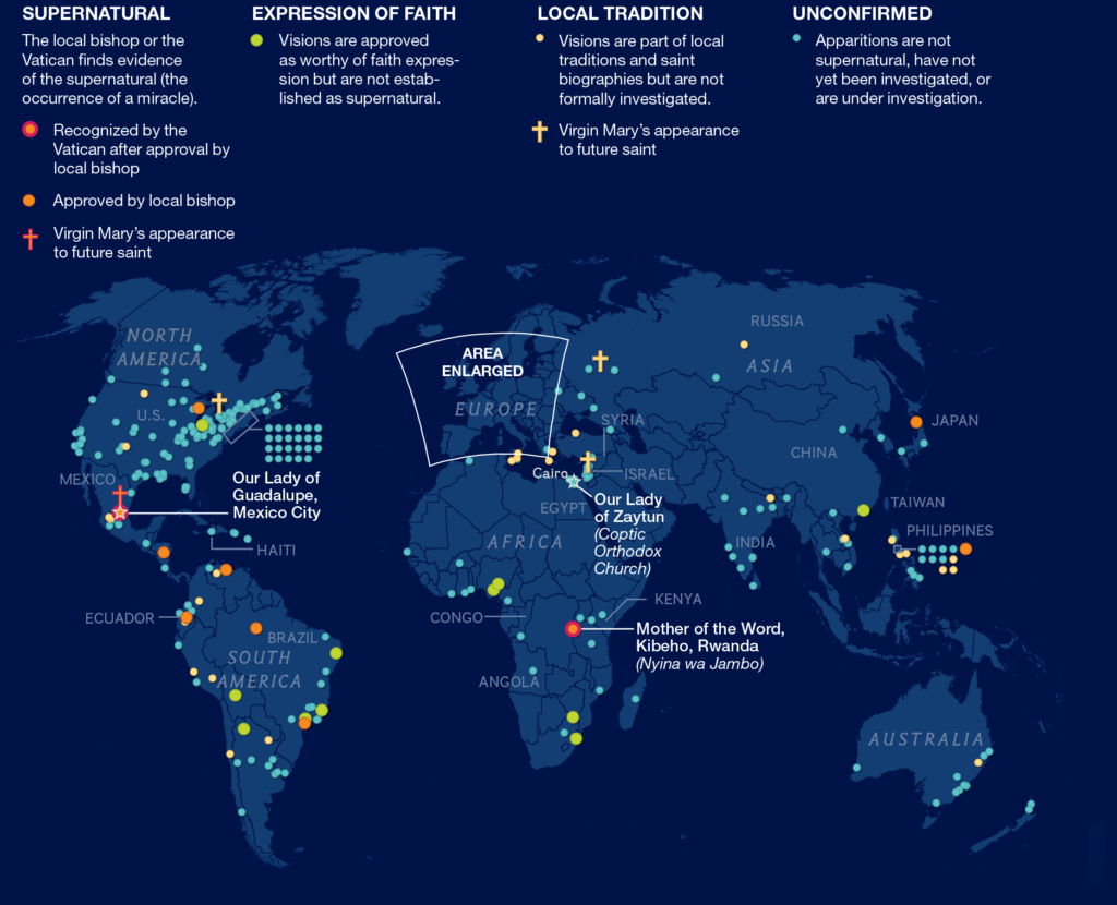
According to the text Virgin Mary barely speaks in the New Testament, but her image and legacy are found and celebrated around the world. The Cult of Mary is often linked to supernatural apparitions and miracle healings. There were over 2,000 sightings of the Virgin Mary claimed since A.D. 40. In the 16th century, the Roman Catholic Church instituted a strict verification process of miracles. The process of investigation covers many aspects of each apparition, including the ‘authenticity’ and mental stability of the seer. To be worthy of belief and church support, apparitions must be deemed miraculous with a high degree of certainty and in line with church doctrine, and found to have had a positive impact. In fact only 16 of them have being sanctioned as true miracles.
The article is summarised with this cool infographic showing where the sightings have been reported, and how they’ve been classified by the church. The map is nicely designed and complemented by a timeline were each apparition has been marked.

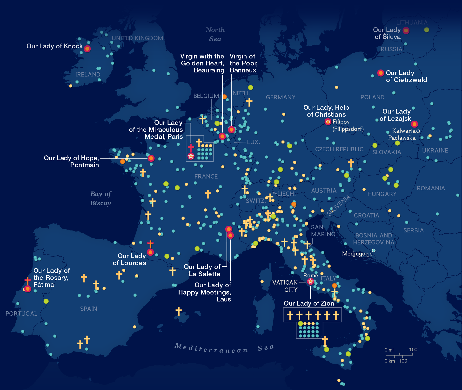
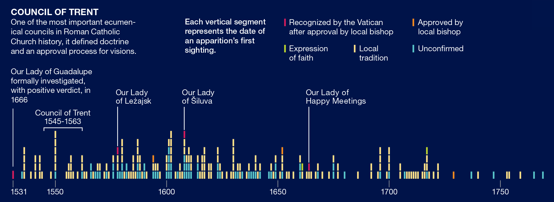
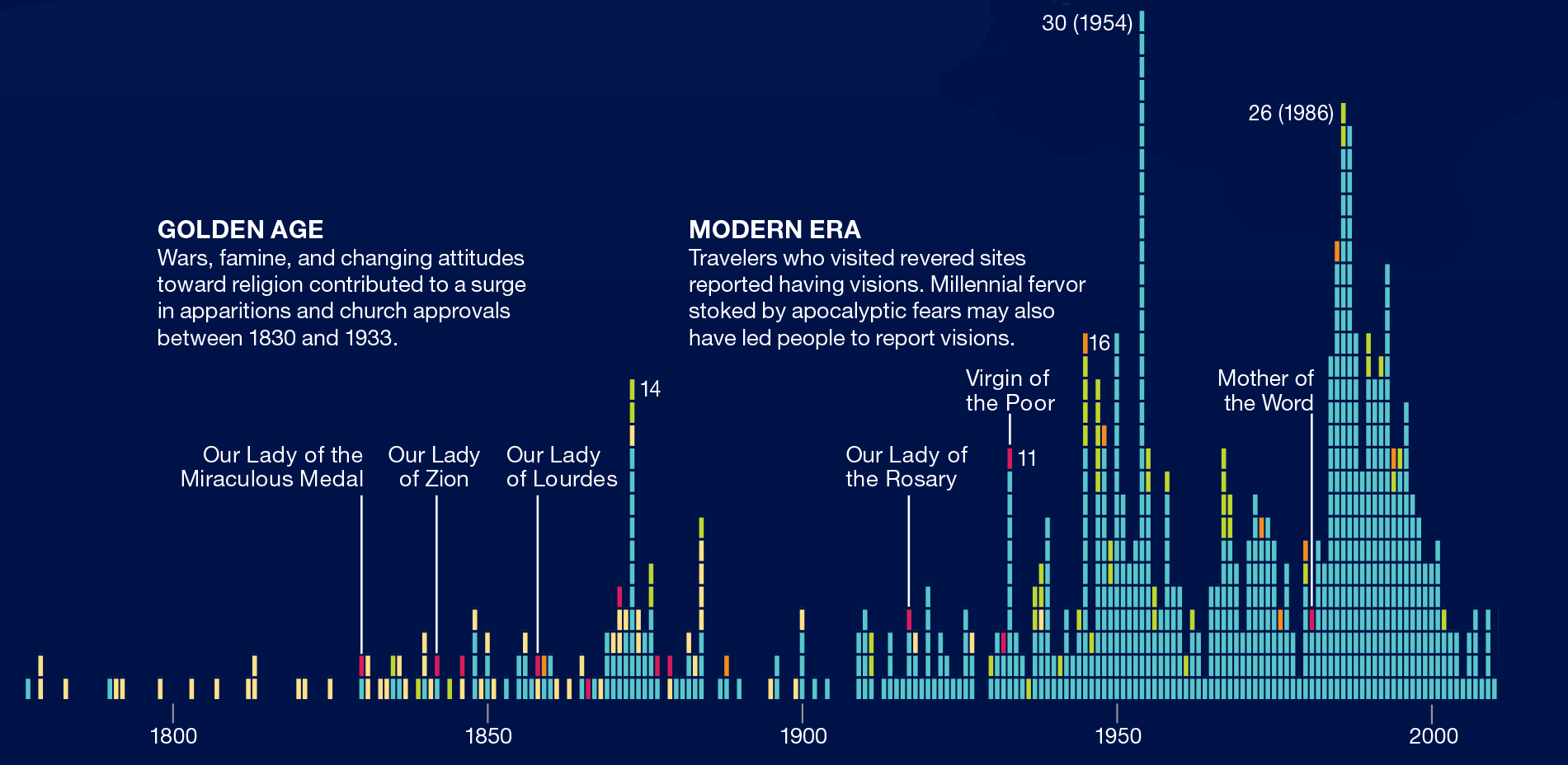
source: National Geographic

#Featured


Next article


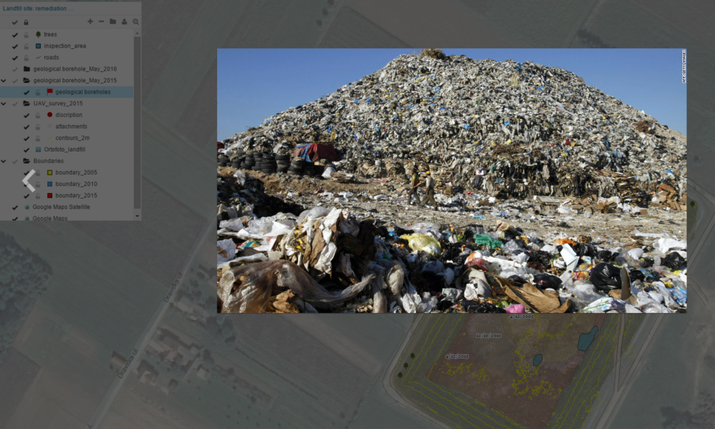
Maintenance and management of solid waste disposal sites includes various tasks such as landfill inspection, reporting, planning and monitoring. Recent advancements in contemporary mapping technology enabled easier management of these activities, as we can see in various landfill management projects. One example is drone mapping which is used for capturing high-quality and up-to-date spatial data and tracking the status of a waste disposal site.
Technology advancements and the emergence of big data mapping systems with great accuracy began to rise multiple questions which are becoming more and more relevant: how should we use collected data, how to filter it, how to share it, how to collaborate? One of the common problems with using big data in different drone mapping projects is connecting all the stakeholders in a particular project, in a real time, with different privileges assigned to different users. How to use and share big raster data sets generated with drones?
In this article, you can read a bit more about using GIS Cloud as collaboration solution in a landfill remediation project, where a survey firm used drone generated images as a basemap for a project plan and monitoring, in coordination with local government agency.
Project Info
Our clients were contracted by the Environmental Protection Agency for the purpose of mapping, monitoring and tracking the status of local sanitation landfill in order to:
1. track and record local sanitary landfill status
2. create a landfill remediation plan
3. conduct monitoring through a 2-year remediation period (2015-2017)
4. produce reports on annual and semi-annual basis, which includes creating digital terrain models and issuing waste volumetric reports.
This project was launched as a legal requirement under the local government jurisdiction and funded through the Environmental Protection Agency. Our clients were required to submit reports to the Agency and local government officials who used this data for submitting to the Office of the Federal Register.
The challenge of collaboration
First task on the agenda for creating a landfill remediation plan was to find a way to include survey firm staff, external associates and landfill management into an effective workflow. Previously, this task took a significant amount of time because they used desktop GIS solutions which required them to manually copy large datasets on DVDs and use printed versions of maps. They wanted to improve the procedure and try to save time and money needed for the project execution. This required a tool for a real-time collaboration between the stakeholders, which was also essential for later phases of a project (monitoring of the remediation process).
Workflow
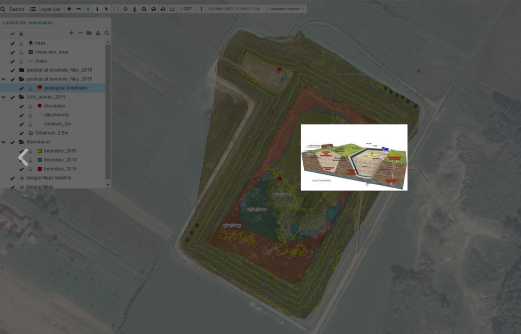
The surveying firm used drones to map about 20 acres of sanitary landfill area, so that they could produce high-quality orthomosaic data and create digital terrain models and issue initial waste volumetric report. After processing a large amount of quality data, these imagery was used as a basemap for further collaboration on a project.
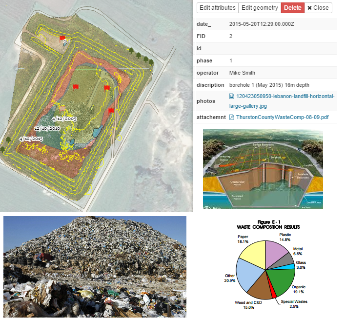
After processing drone generated images, our clients used GIS Cloud’s Map Editor for attaching different types of information (photos from the field, waste volumetric information, pdf documents and reports) to a landfill map.
In this phase, data was shared through the Map Viewer to various stakeholders such as Environmental Office staff, Landfill Manager, Project Manager, and expert geologists. It was important to assess the sanitary landfill status so that a landfill remediation plan could be created and executed.
It was obvious that a cloud-based solution was the answer to the challenge of a real-time collaboration between people involved in the remediation project – they no longer needed to deal with extensive paperwork and rely on their desktop software. In just a few clicks, they were able to load large raster datasets and monitor the landfill status in real time.
Creating a better workflow with Maplim
Survey firm realized that their collaboration process can be further improved by using Maplim, which enabled them to use landfill basemap created with drones as a kind of a workboard for collaboration, both in remediation planning and project execution phases.
You can see an example of their workflow in Maplim in this screenshot:
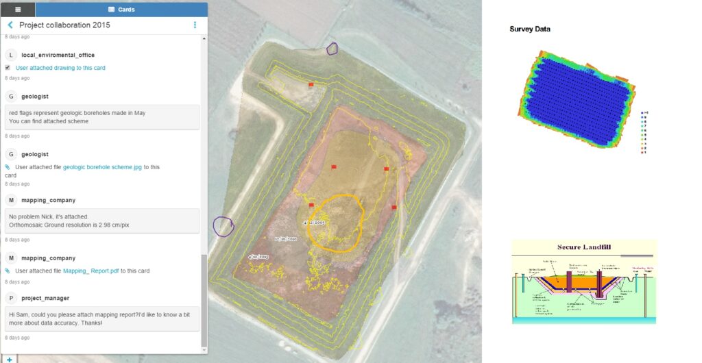
Moreover, as the project progressed, they needed to add extra information from the field and populate the map with field photos, new waste volumetric reports and gas emission and borehole measurements. Field crew was coordinated through landfill manager who communicated with geologists using Maplim. Field crew and geologists used Mobile Data Collection to capture terrain-level photos and update the basemap with up-to-date measurements while collecting samples. Geologists used MDC for pinning locations where they collected samples.
What did we learn?
Mapping with drones enables a large scope of users to map remote or inaccessible areas, and also to update basemaps with real-time high quality data. But, all that data isn’t just a purpose in itself – they serve as a base for making geospatial decisions, which is best achieved through means of collaboration. We tried to show how to “add extra value” to your maps with the help of GIS Cloud’s platform and therefore answer the question about purpose of our geospatial big data – who is using it, why and how can it be utilized in your day-to-day workflows.
GIS Cloud applications used in this project: Map Editor, Map Viewer, Mobile Data Collection, Maplim
Read more at GIS Cloud blog