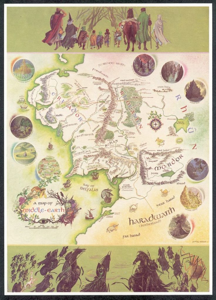

“A Map of Middle-Earth” by Pauline Baynes from 1970
“The Lord of the Rings” trilogy is definitely one my top favourite novels. Actually “The Hobbit” was the first book I’ve ever read and the map of Middle-Earth was one of the first maps I’ve carefully studied piece by piece. Who knows, maybe this is why I got interested in cartography…?
This is why when I heard that news, my heart started to beat faster… A Middle-earth map with annotations by J.R.R. Tolkien has been recently discovered in a copy of the LOTR book owned by illustrator Pauline Baynes, whose coloured map has been published in the 1970 edition of the famous novel.
While working on the map Baynes had been in touch with Tolkien who gave her precise comments. He corrected place names, provided extra ones, and gives Baynes suggestions about the flora and fauna of the Middle-Earth. Hobbiton, he notes, “ is assumed to be approx at latitude of Oxford”.
The map is currently on exhibit in Oxford and can be yours for the asking price of £60,000. Blackwell‘s, the book seller currently in possession of the map, calls it “perhaps the finest piece of Tolkien ephemera to emerge in the last 20 years at least”.
Take a look:
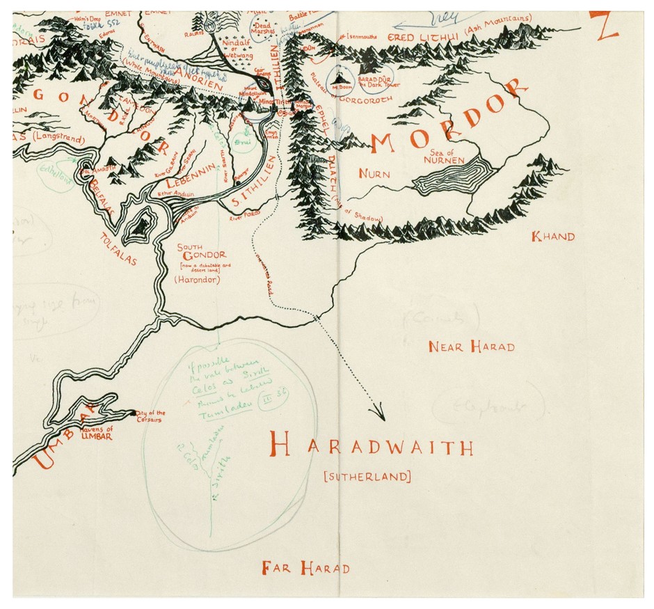
Bottom right corner of the map (Blackwell’s Rare Books)
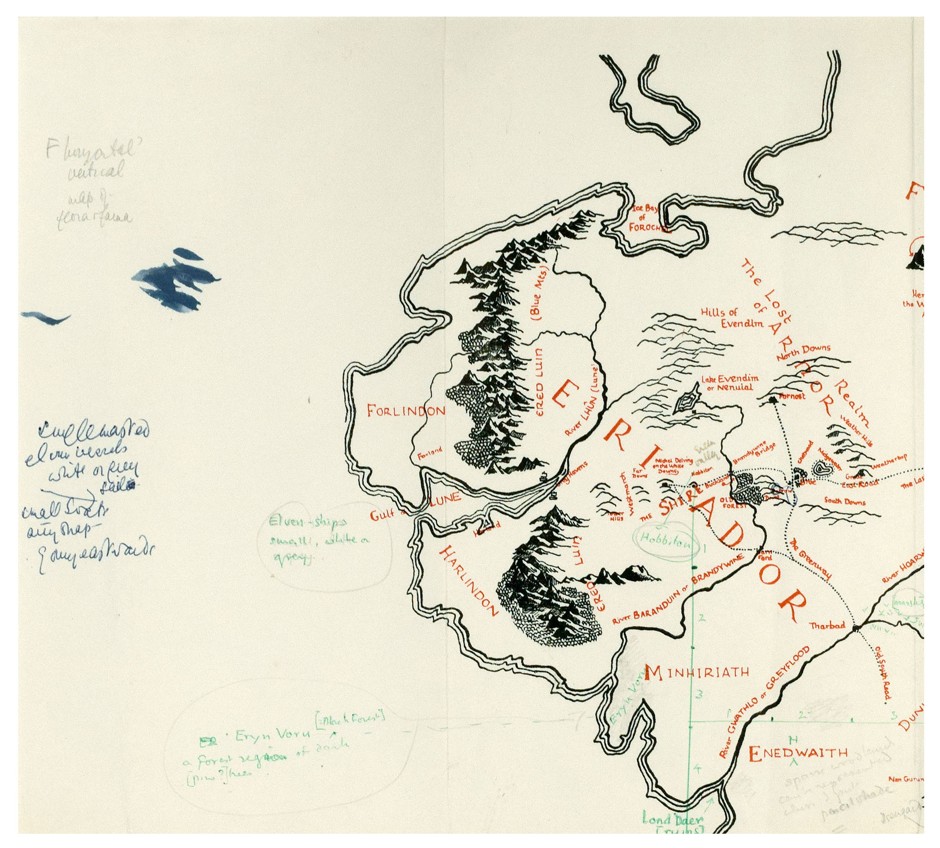
Top left corner of the map. (Blackwell’s Rare Books)
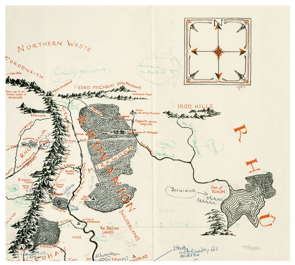
Top right corner of the map. (Blackwell’s Rare Books)
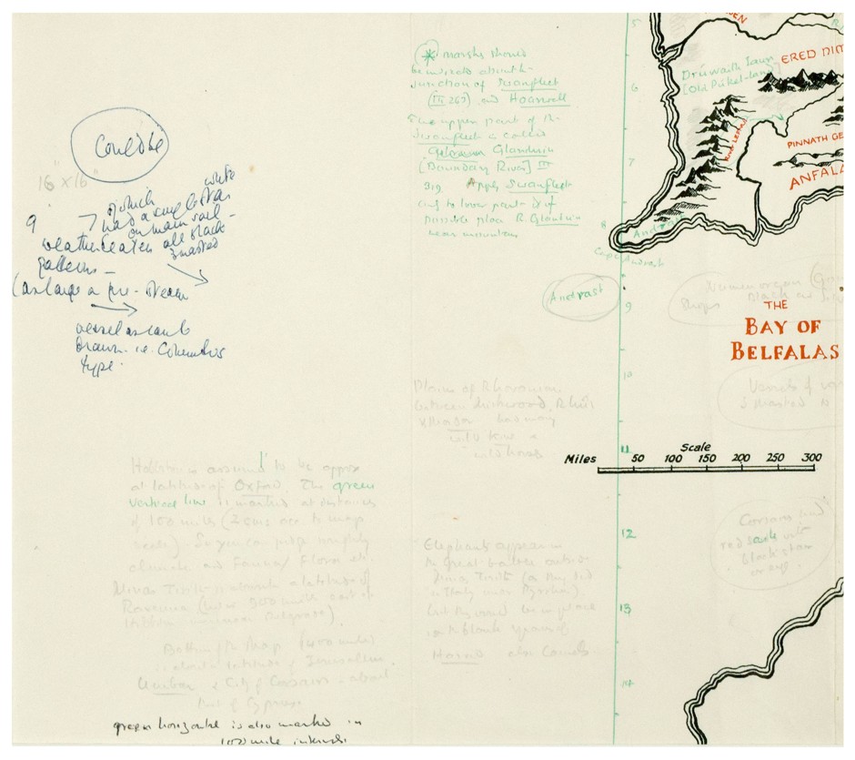
Bottom left corner of the map (Blackwell’s Rare Books)
source: Guardian

#Business


Next article

“We are much more efficient with GIS Cloud as all our clients have access to the same data at the same time. Given that we are primarily at photogrammetry company, much of our datasets are very large rasters that require specialized software and hardware to view. Our clients can now login to GIS Cloud and have the cloud do all the hard work of rendering and resampling.” – Luke Wijnberg, 3DroneMapping
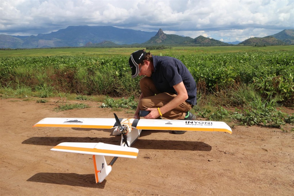
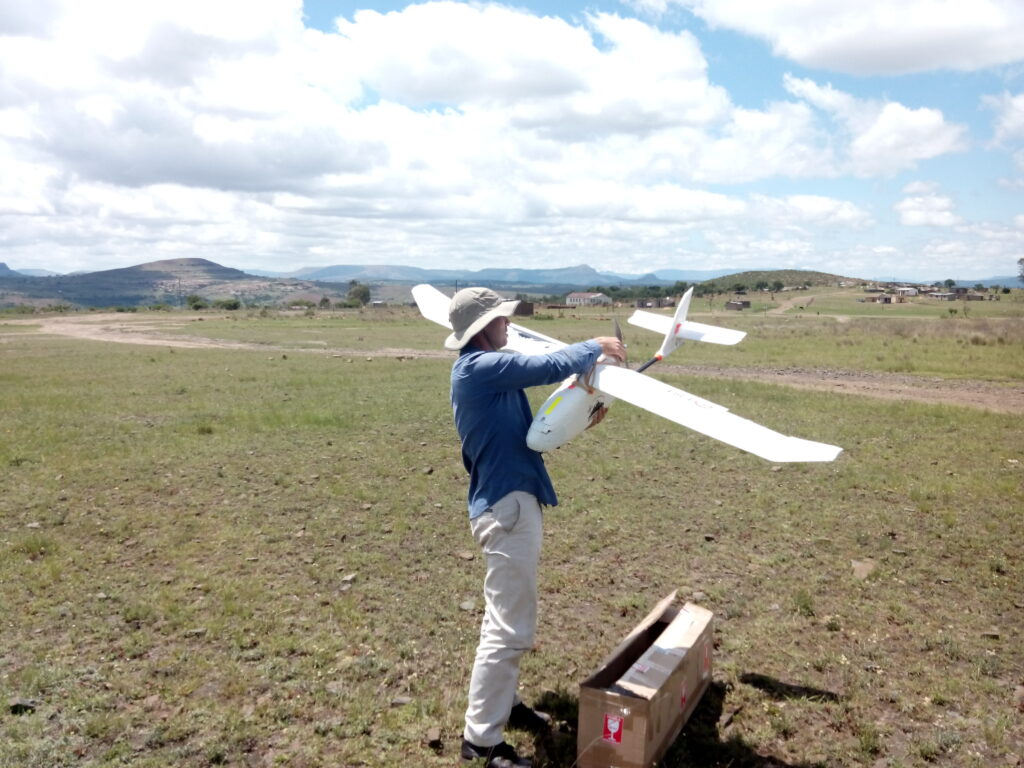
We bring you story of a 3DroneMapping project in Hammarsdale, South Africa. 3DroneMapping began with drone mapping in 2014., making the most of their experience in terrestrial and conventional aerial survey to create a modern approach to undertaking survey, using drone technology. This decision enabled them to offer a service with a very quick turnaround time and low environmental impact, safer and more cost efficient than services with traditional approach using aircraft vehicles.
THE PROJECT
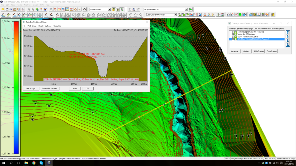
The Hammarsdale project consists of mapping a large-scale (600ha) development area in Hammarsdale, South Africa. 3DroneMapping staff has a task to fly the project every week to produce a high-resolution orthophoto and contours.
Their regular workflow consisted of these steps:
-
- flight planning
- flying over the area planned
- collecting images taken at specific intervals
- processing and referencing the images photogrammetrically
- generating 3D models,
- generating orthophotos and contours,
- uploading the data to GIS Cloud.
During the bulk earthworks part of the project, following this workflow they could accurately issue volumetric reports from week to week for selected areas.
What was the challenge?
All this data needed to be accessed in a controlled manner by a wide variety of end users, such as managers, clients and their various shareholders, subcontractors and other consultants. But, the biggest challenge by far, according to Luke Wijnberg, was to educate people on how to operate a GIS and be able to extract information from it. Both of these challenges needed a solution with a purpose to make their workflow more efficient and as smooth as possible. Summed up by Luke Wijnberg, what they needed was being able to:
- let everyone have the latest copy of our data
- manage different permissions for accessing the sensitive data for each user
- to enable the permanent remote connection between our clients and the project so they could keep track of on-site progress
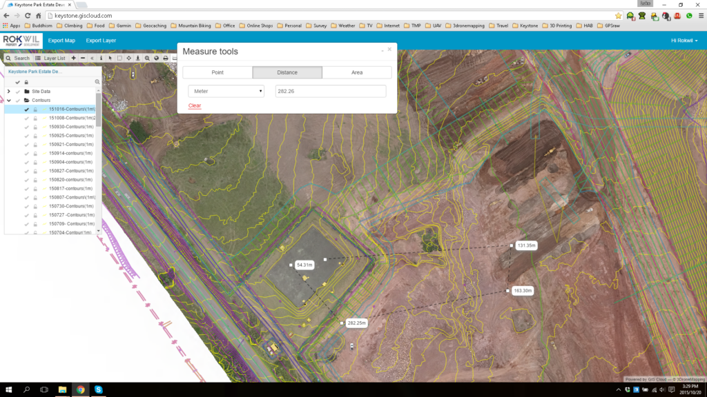
“With GIS Cloud’s easy to use interface on the Web Portal, even the most inexperienced user could measure distances, print maps and query layers. It allowed us to give detailed information to our customers and not have to worry about software licenses/maintenance on their side.”
Therefore, what 3DroneMapping needed was a reliable cloud solution for sharing their field data, both efficient in handling large data sets and easy to use. They choose GIS Cloud’s Map Viewerso that they could share and present the field data to their clients. The interface was easy to cope with so they didn’t have to worry about educating the users how to use it. In their own words: “Have all this data on the cloud meant that the shareholders in Dubai and London could easily track the progress of the construction from their offices and raise their concerns at the weekly meetings.” This enabled them to make their workflow more efficient and reduced their efforts invested in the presentation of the survey results.
“Using a cloud solution allowed everyone to see the entire site as it evolved from a remote location and always have the most up to date data.”
3DroneMapping recommends using GIS Cloud’s Map Portal and Map Viewer for:
- ease of use as a data publisher as it is simple to setup a professional looking map.
- ease of use on the client side as little knowledge of GIS is required to do basic calculations and view results
- sharing large raster datasets as the client does not need any specialized software to view our work.
http://www.giscloud.com/blog/sharing-the-3d-drone-mapping-imagery-with-clients-a-report-from-south-africa/