It is always a good sign for an industry to witness the emergence of entrepreneurial activity. If that is what we go by, then the number of entrepreneurial ventures that sprout each day in the geospatial industry is clearly a sign that Location holds the key to the future 🙂

“The best way to predict the future is to create it” Peter Drucker.
We at Geoawesomeness decided to try and “predict” the future by following some of the interesting start-ups that are making their impact in the spatial Industry (Unwired Labs – Wikipedia , GPSBusinessNews).
I had the pleasure to interact with Mr. Gopi Aravind, CEO of Unwired Labs, a startup from India that is looking to cement its place in the GeoLocation Service Industry.
Thanks for talking to Geoawesomeness, Gopi!
- Unwired Labs is a LaaS startup based out of India.
- We aim is to offer reliable and affordable Geolocation services (Unwired Labs’ LocationAPI) to both developers and companies.
- Currently we have nearly 7000 developers and companies using our API (www.unwiredlabs.com/api) and serve over 3 million requests per day.
- We also supply data to other, larger LBS providers, some very famous ones too.
- While the mandate for most LBS companies now is more accurate location and Indoor technologies get most of the attention these days, Cell tower based positioning is more widely than ever before.
- Some of it’s mature use-cases are being implemented on a larger scale now – from as a backup to GPS, to primary source of location on low-cost M2M devices – and we’re quite optimistic about comparatively newer use-cases such as location based messaging, etc of growing further.
- Oh, our API serves developers and startups all the way through to enterprises and aggregators
- We already offer free accounts for developers and are announcing a free-tier for startups shortly that should help developers bootstrap on our platform
- We’d love to have Geoawesome readers try our platform!
- We source data through manually verified providers such as GPS companies, Android/iOS apps and other aggregators. Our model is to offer lookup credits in-exchange for reliable measures.
- We never war-drive ourselves as it’s not as scalable (in a year of our operations, our database has grown from 2 million cells to over 43 million) or as cost-effective as our present sourcing methods. We don’t let individuals upload measurements either, for reliability reasons.
- We’re opening up our Data Provider API shortly for GPS firms (manual verification) with ideally at-least a 100 units.
- We haven’t had to address privacy concerns as we don’t deal with sensitive WiFi or BT data. That being said, such data help consumers in the end. It’s just another field that needs a better public image.
- Great initiative, though we’ll have to wait and see what happens; how much traction it sustains, how reliable it ends up being
- As with other biggies in this space, it’s not about the quantity of data, but about the quality of data, how it is processed, and finally presented (algorithm maturity, etc)
- It’s a field we’re looking at with keen interest. WiFi based geolocation is too crowded for us to consider getting into.
- We have some interesting ideas to execute here, but for now, we’re focussing completely on Cell Tower based triangulation.
- So far, it’s been a crazy journey.
- The startup ecosystem is witnessing a rapid change with influx of funding and incubators, and a change in the mindset of younger folks who are open to working with startups.
- There’s great engineering talent here too.
- There exchange rate is also extremely favourable considering most of our customers are outside India.
Thanks for your insights, Gopi. Here’s wishing you and your team at Unwired Labs all success!


#Ideas


Next article

Have you ever heard of Unmanned Aerial Vehicle (UAV), commonly known as drones, and its applications in mapping industry? Of course, this question might be irrelevant and you might have already come across various UAVs in the recent couple of years which are now trending in various fields. There are UAVs which can map mountains, which are being used as Tacocoptors and also used for film making etc.
Last week, I have attended India Geospatial Forum at Hyderabad, India and I have come across a lot more new technologies and exchange of ideas at the forum. It was pleasure to attend various technical sessions and demos of various products which made my presence at IGF more memorable.
One among most innovative technologies and an eye catcher in throughout event is AIBOT X6, a drone from Aibotix. Its applications are spread across small scale aerial imaging, mapping and industrial inspections.
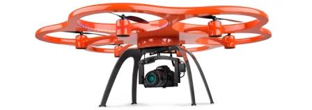
But, I was curious to know what is so special about this UAV when compared to the existing UAVs in GIS market and how it can change the face of GIS aerial mapping for micro scale projects. The fact is, it supports fully automatic and programmatic take-off, flight paths and landing home with real time monitoring during flight with intuitive steering via tablet PC.
Meaning, design your aerial flights using its software or any other software and feed that information to the UAV, mount a Digital SLR (georeferenced) on UAV and then you only need to just click the start button on tablet PC and at the end of the flight, UAV will be at the place where it took off. On other hand, it has got standardized interface for new sensors like RTK GNSS transmitter, Thermal Imager, multispectral cameras, 7-Gas detector and LiDAR 3D laser scanner ect. The application possibilities are almost endless.
I believe, this video can demonstrate it in a better way and here are more demo videos.
Wowwww !!! Isn’t it so amazing to accomplish your aerial mapping project as simple as I said? What’s in your mind? Would UAVs change the face of Aerial mapping for small scale projects?
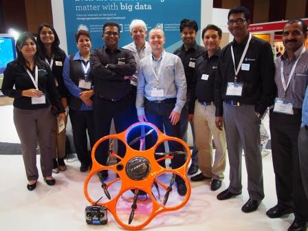
Here is the team behind the show !!!