

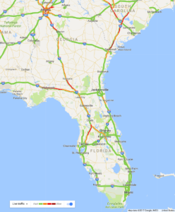
 As Florida braces for Hurricane Irma’s impact over this weekend, Governor Rick Scott is urging citizens to leverage technology to stay safe and updated about the situation on the ground. The state’s disaster preparation officials are working with Google’s crisis response team to reflect road closures in Google Maps in real-time.
Gov. Scott said in a press conference, “We have traffic cameras on every major roadway in the state and are clearing traffic issues in real-time, so we can keep people moving.” So, if the state is forced to close any roads in the aftermath of the storm, a quick Google Search will allow people to find out the state of the road network around them.
Though Google’s crowdsourcing app Waze also reflects real-time traffic alerts submitted by users, incorporating road closure information directly into Google Maps will save the precious time of people looking to evacuate and help them navigate around closed roads quickly.
Google also released a statement about its efforts, saying, “Our thoughts are with those affected by Hurricane Irma. To provide access to accurate and useful transportation information, we use algorithmic and manual methods to account for everyday and emergency road closures. We’re working directly with Florida officials to help provide up-to-date information to those affected by the storm. These road closures will also appear on our Irma Crisis Map, embedded as part of our SOS Alert on Search.”
Technology-driven disaster response
Apart from Google Maps, the state also officially recommended using the Gas Buddy app to find out which filling stations had fuel available, and which were not operational. Gas Buddy has updated its app to reflect easy-to-read ‘no gas’ and ‘no power’ symbols. Gov. Scott also noted that travel site Expedia will be updating hotel occupancy rates in real-time. And we have already seen during Hurricane Harvey how Snapchat’s location-sharing tool Snap Map became the go-to resource for people trying to check on their family, friends, and family.
It’s in times like these that you truly understand how spatial technologies help people to come together in a focused manner and give them the information they need much more quickly.

#Business


Next article
Have you ever looked at a Google Street View picture and felt that the image looks a li’l washed out? Like this one:
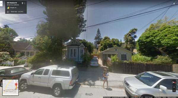
It’s because the Street View cars have been using the same cameras since 2009! They have traveled almost 10 million miles, covered every single continent and 83 countries in total without any major step-up in the imaging hardware. Imagine being stuck with a 2009-era resolution camera in your phone for 8 years… *shudder*
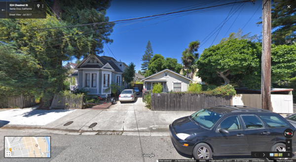
Thankfully, things are changing as the good folks at Google finally upgraded the camera rig last month, Wired reports. So, now we can see the world in higher resolution and much brighter colors, like this:
And here comes the interesting part: Google didn’t give its Street View cars 20-megapixels of sensory power for aesthetic reasons alone. Google needs the HD images of the world around us because they make the work of its AI-based image recognition algorithms easier.
Related: Google’s Street View turns 10!
By allowing its sophisticated algorithms to soak in every little detail on each street – signs, business names or even the opening hours on a store sign – Google wants to stock up its digital mapping database with an unparalleled amount of information… Information that would power its Maps, Search and Assistant products.
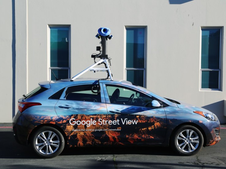
The new, fancy camera rig on a Street View car
For example, Google doesn’t want to just answer questions like “Which restaurants offer Chinese cuisine in my locality?”, it wants to solve much more complex and conversational queries like, “What’s the name of that Chinese restaurant next to the supermarket and will it deliver to my place at this hour?”
We already know that Google’s algorithm has become so perfect that over one-third of addresses globally have had their location improved through deep learning technology. So, whenever a Street View car drives on a new location, the system analyzes the tens of thousands of images to extract the street names and numbers, and automatically create the new addresses on Google Maps.
And now, with higher quality images coming in through the new hardware, things are only going to get better!