
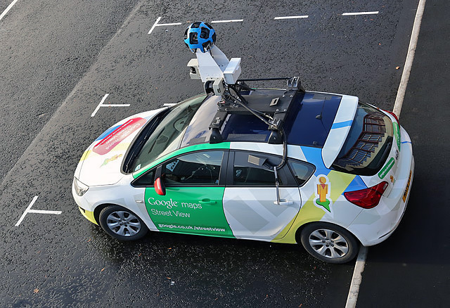
 When Google first introduced Street View, all it wanted to do was to provide panoramic views of the real world in its Maps. But then, as mobile devices and Google Maps shot up in popularity, the value of local search became obvious. And Google, as expected, became obsessed with providing accurate listings of local businesses across the world. In its possession were billions of high-res images captured by its Street View cars. But, who would analyze them? The task just didn’t seem humanly possible.
Enter, the wonders called machine learning and computer vision.
Today, after almost a decade of research, Google’s algorithm has become so perfect that over one-third of addresses globally have had their location improved through deep learning technology which recognizes text in its natural environment.
Google revealed in a blog post that this algorithm achieved an accuracy score of 84.2% on the very tricky French Street Name Signs dataset, which comprises of more than 1 million street names. This result is a radical improvement over earlier state-of-the-art systems. So much so, it has led to improvement in over 90% of the addresses in Brazil!
Google says, “Now, whenever a Street View car drives on a newly built road, our system can analyze the tens of thousands of images that would be captured, extract the street names and numbers, and properly create and locate the new addresses, automatically, on Google Maps.”
But, automatic address generation still doesn’t solve the purpose of local search – providing navigation to businesses by their name. So, the search engine giant proposed one more approach that would read store-front signs in Street View images. This model was trained extract ‘structured text’ from the imagery – meaning it would only keep that text which is relevant.
And here comes the cherry on the deep learning cake. Google has announced that it has opened the algorithm behind this model to the general public on GitHub through Tensorflow. This means, any developer can use it for automatic extraction of information from geo-located imagery. Go nuts, guys!

#Business


Next article

As you are here I’m guessing that the term GIS has popped up at work. Maybe your organization has decided to start using GIS to make better sense of their data, or you were looking into ways to map your data, and that search led you to the term “GIS”.

If like me, the first thing you did when you heard this term was head over to Wikipedia, you will have been confronted with lots of complex jargon and even some scary looking algorithms:

Formula for calculating aspect in GIS, Wikipedia
Now, before you get disheartened or fall asleep, I have some good news for you!
GIS isn’t that complicated, what’s more it can even be fun. Once you’ve finished this short book not only will you understand what GIS is all about, but you will have the background knowledge and vocabulary required to discuss GIS and its associated tools with confidence.
You will even learn the basics of operating a GIS, preparing map data and publishing interactive web maps.
What is GIS?
GIS stands for “Geographic Information System”. GIS is a very broad term, and trying to get a consistent definition can be tricky. Ask ten different GIS users and you will likely get ten different answers.
It could be argued (and the propeller heads often do) that any digital data that contains location based information is in fact a GIS.
This location information in the GIS industry is called “spatial data” and it could be an address, coordinates containing latitude and longitude or complex three dimensional geometry.
But you’re not here to get into semantics, or bogged down in jargon, I’m guessing you are here because you want to know what the majority of people mean when they say GIS, and more importantly how it can be of value to you and your organization.
What does a GIS do?
The truth is that it can do a lot of things, but here’s the short answer: A GIS allows you to visualize your data as a map.

Maps + Data = GIS
What’s more, GIS systems aren’t static. They allow us to ask complex questions—or “queries” as they are called in GIS speak—anytime we like. A GIS system can answer these questions instantly by modifying colors, shapes or highlighting locations on the map.
We’re visual creatures that possess an innate ability to visualize patterns. Patterns that might take us hours to identify in a spreadsheet can often be identified in an instant when displayed in a more visually engaging format like a graph, chart, or in this case a map.
There are many innovative ways that your data can be displayed on a map. It could be plotting markers, color coding locations based on an a data value or using heat maps to identify clusters and patterns in your data, the possibilities and potential insights are literally endless.

Data can be visualized in endless ways
What’s more, GIS systems aren’t static. They allow us to ask complex questions—or “queries” as they are called in GIS speak—anytime we like. A GIS system can answer these questions instantly by modifying colors, shapes or highlighting locations on the map
Do I need a GIS?
The truth is that GIS is merely a tool, it’s just a means to an end. Most people don’t need a GIS, what they really need is the answer to a question. A GIS simply provides us with a more efficient mechanism of obtaining that answer.
So the question to ask yourself is this; will the benefits of being able to visualize my data on a map and quickly answer questions that are location specific, provide me with a return on the time taken to get up to speed on GIS?
I’ll give you a clue: if data is a core part of your business then the answer starts with “y”, ends in “s” and contains an “e” in the middle.
By the time you’ve finished this book — it’s pretty short, so shouldn’t take you long — I’m confident that you will be excited about the possibilities that GIS holds for your business.
Location is a powerful element of your data that, until now, you have likely been neglecting. You obviously know the what and when, and you probably know the how. But do you really understand the where?
I’ll guarantee there are patterns in your data that have been right under your nose this whole time, but you just haven’t been able to see them. A GIS system will shine a bright light on those patterns and make them clear for all to see.
How Much Does GIS Cost?
So I can hear you thinking:
“That all sounds great, but be straight with me—am I going to need to sell a kidney?”
I can’t say that it’s never happened, but you’ll be pleased to know that most of us that benefit from GIS still possess two functioning kidneys!
There are some great free and open source tools available, lots of affordable desktop and web tools (Mango, nudge nudge, wink wink) and also some very expensive solutions at the top that service very niche use cases.
Later in the book we will be taking a more indepth look at the various open source and paid GIS software solutions, both on the desktop and the web.
In most cases the main cost of GIS will be in time rather than software licensing. Which brings us neatly onto the next question.
Can I do GIS for myself?
If you listen to the consultants, then a long winded buzzword-filled answer will eventually arrive at a negative. But isn’t that always the case with consultants?

The truth is that you can do it yourself using freely available tools and some self-study.
And I know, because that’s the way I learned GIS.
I’m a software engineer by trade, and managed to make it well into my twenties completely oblivious to the mysterious world of GIS.
Then one day I’m in a meeting with a client. They mention to me that they would like move their GIS system online and enquired whether or not I could do it.
Like every young and overly keen consultant, I nodded away as if knew what he was talking about and assured him that I could deliver a superb online IGS, hang-on, or was it GIS?
After the meeting I combed the internet and began to realise what I had got myself into. This GIS stuff looked pretty tricky to say the least—jargon galore, and very complicated looking tools.
Luckily I persevered and managed to learn just enough to make it to the next meeting and maintain a very thin veneer of understanding and confidence.
That was ten years ago. Since then I’ve been a partner in a GIS consultancy company and more recently founded Mango, a web tool that makes it easy for non-coders to create and share GIS web applications.
I’m effectively a GIS immigrant, I didn’t learn it in college — I stumbled across it completely by mistake. I think this gives me a unique perspective, and I’m confident that you too can quickly learn enough GIS to provide tangible value to your work.
And I can assure you of this: GIS is a great skill to have under your belt. It’s always looks good on a CV, because it’s something that most companies know they should be doing more of but haven’t had the personnel to get the ball rolling.
How long does GIS take to learn?
Now I’m not going to pretend that GIS is simple, it can in some instances be extremely complex, but like most things it follows the 80/20 rule: you only really need to learn 20% of what’s possible in order to enjoy 80% of the benefits.
If you tried to learn every aspect of GIS it could take a lifetime, a far better approach is to get a good idea of what’s possible and then zero in on the parts that will be of benefit to you and your business.
That’s where this book comes in, this book isn’t going to teach you to become a GIS expert. My objective is to give you an introduction to what’s possible and get you acquainted with some common use cases, tools and terminology.
This will be the foundation you need to zero in the parts that will benefit you the most.
For example, a common GIS use case is business analysis. In this case you will be most interested in how to transform tabular data — like spreadsheets — into a map-ready format, and then build visualizations that highlight sales trends or sales territories.
What you don’t need to understand is how to process LIDAR data or orthorectify an aerial photograph. Don’t worry if you don’t understand what those things mean, truth be told, I don’t really understand them either 😉.
You see, as with all technical professions there are some professionals that like to make it all sound much more complicated than it really is. But don’t let them put you off, most of these things that sound so complex can be learned in an afternoon.