Aeolus, the wind satellite launched by the European Space Agency (ESA) in August 2018, is ready to share its novel observations with the world. Weather forecasting services and scientific users can now access the data captured by Aeolus in less than three hours of measurements being made from space.
The availability of Aeolus data beyond its core user community is significant because Aeolus is the first satellite mission to directly profile Earth’s winds from space. Not only can its data be used to understand how wind, pressure, temperature, and humidity are interlinked in climate research, but it can also contribute to near-real-time weather forecasting
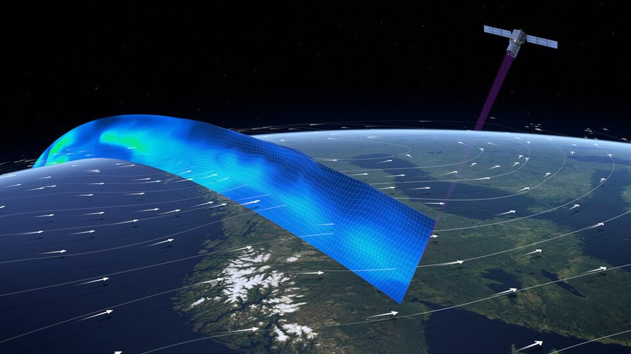
The earth exploration mission is aptly named after Aeolus from Greek mythology, who was appointed as the ‘keeper of the winds’ by the Gods. The satellite carries one of the most sophisticated scientific instruments ever to be put into orbit – the Aladin.
The Aladin leverages breakthrough Doppler LiDAR (light detection and ranging) technology to generate pulses of ultraviolet light that are beamed down into the atmosphere to profile the world’s winds.
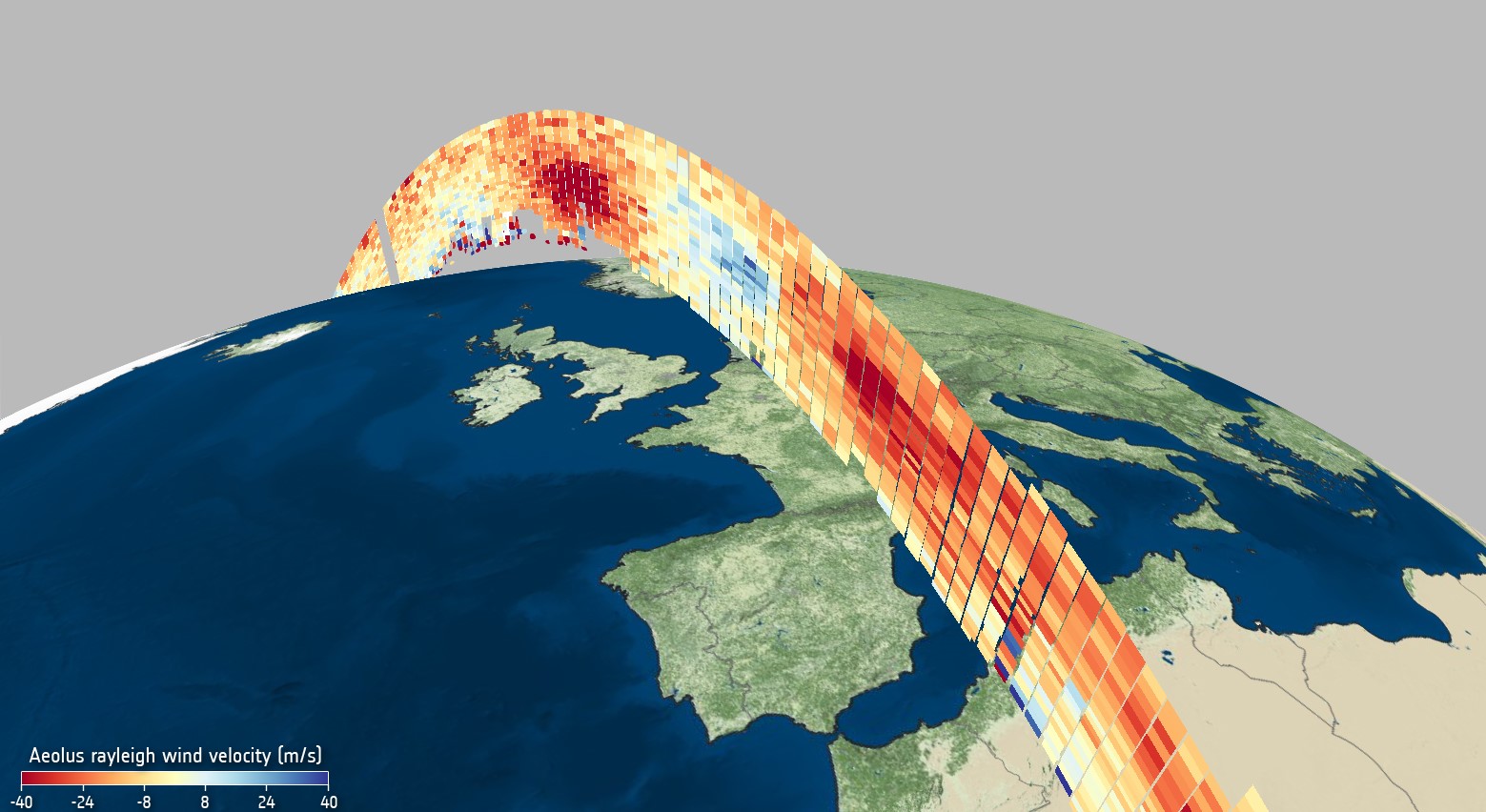
Wind profile from Aeolus
How the wind influences the exchange of heat and moisture between Earth’s surface and the atmosphere is an important aspect of understanding weather phenomena like climate change. According to ESA’s Peggy Fischer, a huge amount of work went into perfecting Aeolus’ data before the data was made accessible to the public.
“This satellite technology is completely new so we have had to understand and correct certain biases in the data that were not known before launch. To do this, key Aeolus experts from different organizations worked together in the Data Innovation and Science Cluster team – the Aeolus DISC, to validate and optimize the data processing and bias correction methods,” Fischer explained.
The data will be distributed by the European Organization for the Exploitation of Meteorological Satellites or EUMETSAT. European national weather services and the entire World Meteorological Organization (WMO) community will be the immediate beneficiaries of Aeolus near-real-time wind products.
Interesting: It snowed in Sahara and we cannot stop staring at pictures

#


Next article

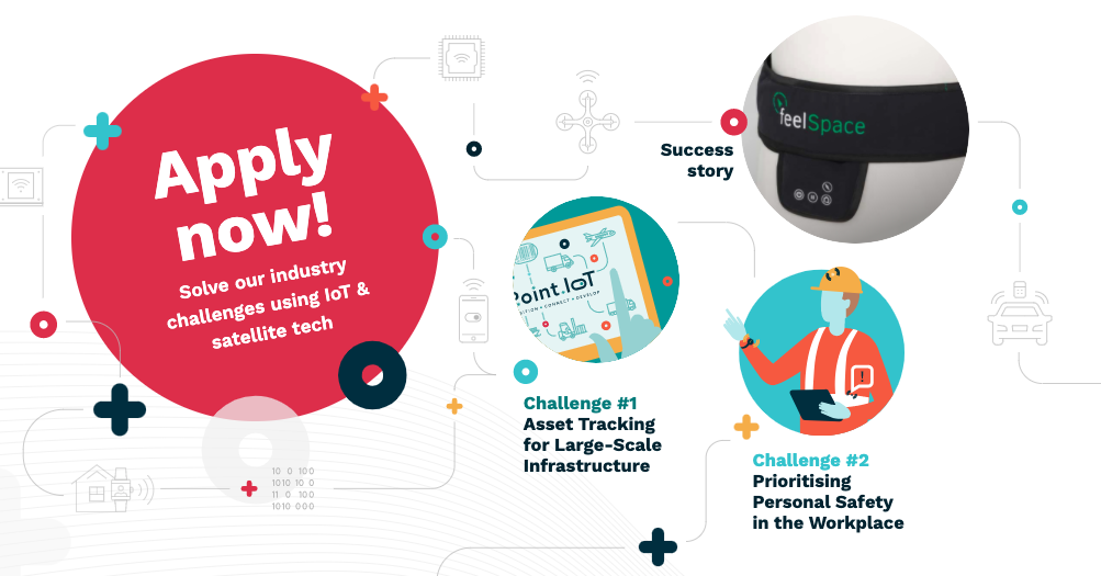
If you are a budding entrepreneur who is keen on using IoT and Satellite tech (Galileo) to solve industry problems, congratulations you are in luck! Point.IoT, an exciting new programme funded by the European GNSS Agency (GSA) is just the right platform for you.
Empowering Innovation using Galileo and IoT technologies
Point IoT has been designed to empower innovative entrepreneurs to solve industry problems through the use of Galileo and IoT technologies. Each year, ten teams of ambitious entrepreneurs will have the chance to roll up their sleeves and tackle relevant industry challenges while showcasing the use of European positioning technologies in IoT. The best part about the challenge (besides the cash award, access to funding and recognition)? Point IoT has partnered with real companies facing real challenges. At the end of the program, you not only have the chance to win €20,000 but maybe also your first corporate customer!
What are the industry challenges for 2020?
- Challenge #1: Asset Tracking for Large-Scale Infrastructure
- Challenge #2: Prioritising Personal Safety in the Workplace
How long is the programme? What are the steps involved?
The programme kicks off with a two-day action-packed bootcamp in Paris, France where teams learn essential tools for their work ahead. They’ll then return home for a three-month virtual sprint and receive one-on-one coaching from industry experts to ensure their solutions are both technically robust and strategically positioned for market success. The programme ends with a demo day when the most talented team will be awarded a grand cash prize of €20,000 – and maybe their first corporate customer!
I’m interested! How do I apply/get more information?
28th June 2020 is the deadline for applying to the program with your idea. You’ll find all the information you are looking for regarding who can apply, what the challenges mean, what support you can expect, who are the mentors, and more on their website.