


It took 150,000 years for humans to touch the 1-billion population mark. Today, there are over 7.5 billion of us on this planet. Of these, 2 billion have been added after 1993 – in the last 24 years. According to the United Nations, our population is expected to reach 9.8 billion by 2050 and 11.2 billion by 2100. And that, many scientists believe, is the maximum carrying capacity of the earth.
The issue isn’t the number of people. If a space to provide shelter is all we were focusing on, there is enough room for all of us. The trouble begins when we start measuring the ecological footprint of this burgeoning population – the amount of biologically productive land and water a person requires for producing the resources it consumes.
The Food and Agriculture Organization of the UN says that some 11% of the globe’s land surface is being used for growing crops at the present. An even bigger area is being employed for livestock grazing. To produce 1 kg of wheat, between 500 and 4,000 liters of water is needed. 1 kg of chocolate, meanwhile, requires a whopping 17,196 liters of water. Another 15,415 liters of water go into producing 1 kg of beef, while 1 kg of chicken meat necessitates expending 4,325 liters of water.
Accordingly, the ecological footprint – measured in global hectares per capita – is highest for the countries of Luxembourg (15.82 gha/person), Aruba (11.88 gha/person) and Qatar (10.8 gha/person). Conversely, countries like Pakistan and Bangladesh have an ecological footprint of only 0.79 gha/person and 0.72 gha/person, respectively.
To put these figures into perspective, consider this: If all humans started living at the standards of Qatar, we would need another four earths to sustain ourselves. And this is without factoring in the additional stress that would arise if we put climate change into the equation. Rising sea levels in China and changes in precipitation patterns in some parts of Africa are just a couple of examples of how scientists are worrying about these regions’ capability to support human habitation and agriculture in the future.
Harvard University scientist Edward O. Wilson wrote in his 2002 book The Future of Life, “If everyone agreed to become vegetarian, leaving little or nothing for livestock, the present 1.4 billion hectares of arable land (3.5 billion acres) would support about 10 billion people.” Now, it’s extremely unlikely that we all will stop eating meat. But considering the progress in agri-technologies over the years, the maximum carrying capacity of our planet can still be safely capped at around 10 billion people as far as food is concerned.
Check out a video by Life Noggin below which takes an interesting look on the subject:
It is ultimately upon advancements in science and technology and people’s willingness to change their lifestyles to make this world more viable for our future generations. As Mahatma Gandhi famously said, “The world has enough for everyone’s need, but not enough for everyone’s greed.”

#Environment


Next article
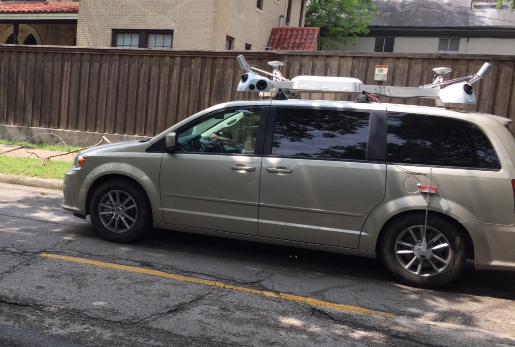
 It is no secret that Apple has been driving vehicles around the world to collect data which it says will be used to improve Apple Maps. The company even has its website detailing when and where you can expect to find these automobiles. One such vehicle was recently spotted in New York, and the amount of hardware fastened onto its roof has got us believing that Apple Maps is soon going to get a sensational upgrade.
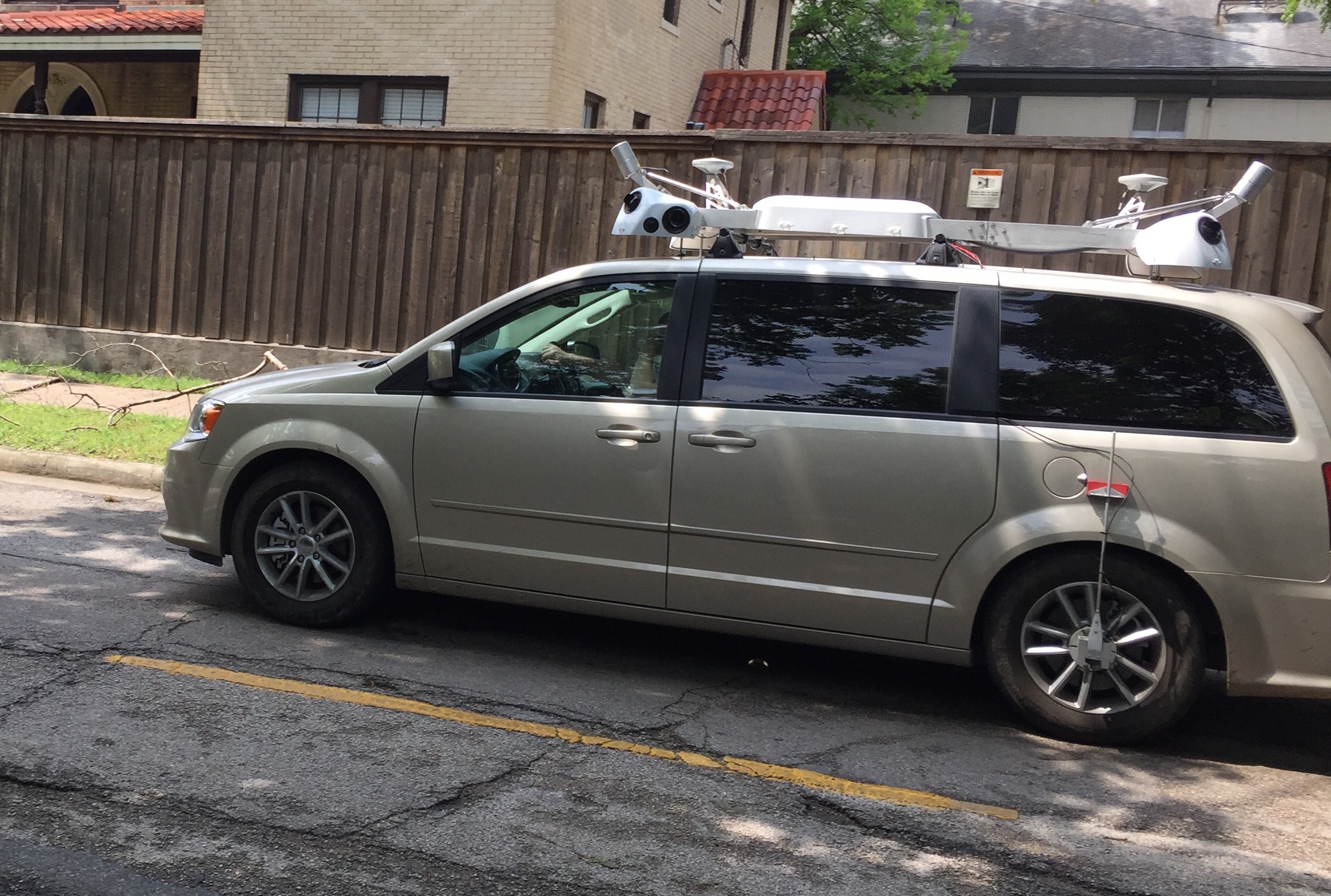
So what exactly does this hardware consist of? Well, we have counted a GPS antenna, six wide-angled cameras (three on each side), a camera each on the front and the back, and (drumrolls, please!) four Velodyne LiDAR sensors. Now, we know LiDAR is the go-to perception sensor for self-driving cars, a project Apple is also interested in. Having four LiDARs bolted on its top gives the Apple vehicle 360-degree, 3D view of its surroundings, as well as calibrated reflectivity data for precise positioning and object classification and tracking within that environment.
All this indicates that Apple Maps is possibly getting a massive upgrade in the form of 3D street view. Or is may be possible that Apple is killing two birds with one stone here: Getting data so precise that not only can it lend 3D street view capabilities to its Maps, it can also use the same data to power its autonomous vehicles project! Considering that the vehicle which was spotted carried a clear Apple Maps branding, let’s stick to the first theory for now.
Ever since Apple made its disastrous Maps debut in 2012, it has struggled to keep up with Google. Having 3D street view may finally give Apple Maps an edge over the Google counterpart as Google simply stitches multiple images together to create Street View and hence its product lacks true depth.
With the upcoming iOS 11, Apple is preparing millions of iPhones and iPads to be used as Augmented Reality (AR) viewers. Making Apple Maps AR-enabled using this 3D street view data would make perfect sense for the company. We already know that iOS 11 is going to introduce indoor maps for malls and airports in the United States, as well as for international locations. And iOS 11 public beta users are reporting a 3D ‘flyover’ mode in Maps reminiscent of Google Earth virtual reality. All in all, it’s heartening to see Apple really stepping up efforts to make its Maps better.