
OpenStreetMap is a crowdsource project to create a free editable map of the world. By this means you can use OSM data in any GIS or mapping project, both privately and commercially.
If you ever needed to use OSM data in your GIS project you must have faced the same challenge… How to download OpenStreetData in GIS format? In fact it is easier than you might think. There are a couple of websites that allow you to simply download OSM data. Here is the list of the most user-friendly tools to do that:
Companies
| wdt_ID | Organization Name | Industries | Headquarters City | Headquarters State | Headquarters Country | Total Funding (in USD) | Operating Status | Founded | Full Description | Website |
|---|---|---|---|---|---|---|---|---|---|---|
| Organization Name | Industries | Headquarters City | Headquarters State | Headquarters Country | Total Funding (in USD) | Operating Status | Founded | Full Description | Website |
Some of these tools don’t support downloading data in ShapeFile format or offer it as a paid service as PBF is a primary format of OSM data. You shouldn’t be too worried about it. The are multiple converters available online but most of them are based on command line which is not that convenient. There is however a simple way to do that in QGIS. You simply add to the map a PBF file as a vector layer and save it as SHP.
Voilà!

#GeoDev
Next article
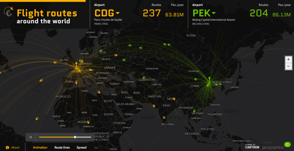

Awesome mapping project by Geographica a Spanish map design studio. The Flight Routes Around the World is an interactive map that visualises data about the world’s 50 busiest airports by passenger traffic.
For each airport you can visualise the number of routes and their destinations as well as the number of passengers per year. You can also compare two different airports by selecting them from a dropdown list in the top menu.
The map itself is based on CartoDB. The design is simple, clean and it does the job well. The code of the project avaiable on GitHub. The data comes from Wikipedia, OpenFlights.org and OurAirports.com.
What can I say. We wish more projects like that!