


For 12 years now, Esri DevSummit continues to be the globally premier conference for geospatial developers, and next week, for the 5th year in a row, we’re hosting a DevSummit in Washington DC. Year after year, this event continues to grow, with more attendees, Esri staff, and technical workshops than ever before.
This premier event “For Developers, By Developers” will be held at the Walter E. Washington DC Convention Center on Wednesday, February 15th. Whether or not you just attended Esri’s Federal GIS Conference on Monday and Tuesday, if you are a developer, we encourage you to come on by. We have a full slate of technical workshops covering the entire ArcGIS platform. If you are extending ArcGIS applications, designing and administering enterprise systems that include ArcGIS, or building mapping and GIS apps for desktops, devices, and the web, this intensive developer day is for you.
DevSummit is more than just a conference. We have designed the technical session agenda in order to make it a productivity event. You are not only going to see, hear about, and discuss the latest products and functionality, you will also be able to put them to use right away. And in this way, DevSummit attendees will always have the competitive edge.
With over 75 technical sessions, you will learn about capabilities of the ArcGIS platform that are new, enhanced, and expanded. If you have been working with ArcGIS for years, we have the deep dive sessions you want, and if you are new to the platform, we have the best introductory sessions for getting you started. Here’s a short list of sessions we’d like to highlight:
- ArcGIS API for JavaScript: What’s New at version 4x
- Artificial Intelligence: Geo Deep Learning with Big Data and ArcGIS
- Security and ArcGIS Web Development
- Geodatabase Programming with SQL and Python
- Building Apps and Add-ins with the ArcGIS for Defense Solution
- ArcGIS Web AppBuilder: Customizing and Extending
- ArcGIS Python API: an Introduction
- ArcGIS Open Data for Developers
The sessions are intense, 45 minutes each, with 15 minute breaks in between. The morning starts with some carbs and coffee to kick things off, a hearty lunch in the noon hour, and then a “Meet the Presenters” social at 5:00pm where you can have productive one-on-one discussions with Esri developers who build, and build-on the ArcGIS platform.
If you want to join the conversation use the hashtag #DevSummit and follow @EsriDevSummit on Twitter, Facebook.


#People


Next article

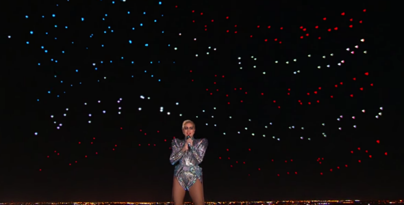
Drones have stolen the show of this year’s Super Bowl Half Time performance. A fleet of Intel’s 300 flying devices was dancing behind Lady Gaga as she stood on the roof of Houston’s NRG Stadium. It was an amazing show, and I’m sure it’s not the last time you’ve seen drones used to light up the skies during an event like that. But I believe that this performance is not all about entertainment, but it marks a significant milestone for drone industry and in particular UAV mapping area.
Today, UAVs are typically controlled by human operators, that have to plan the flight (or use an app to do that), go to the field, launch a drone, complete the survey in single or multiple rounds. Then they need to process the source data to get the result which is a 3D terrain model or other cartometric imagery-based product.
The scope of the project is limited by a range of the drone and the required resolution. The range depends on the battery life. Normally, fixed wing drones can survey up to several square miles and rotary drones below 0.1 mi2. The rotary drones offer however a higher spatial resolution that can be as small as 1mm, while with a fixed-wing device we talk about over a centimetre level of accuracy.
So if you have a large object to survey, you need multiple drones with multiple operators or one operator that gradually collects data for the whole project area. It complicates the operations in the field, increases the cost and compromises the temporal resolution (refresh of a given area to compare what has changed over time). For some objects like long power lines or pipelines, large-scale drone inspection might not be an option at all.
Lady Gaga’s Super Bowl Half Time shows that the drone control technology will soon allow what was previously impossible. Imagine that an operator controls not a single UAV but a whole fleet of dozens of autonomous flying robots. The central system divides the survey area between them. Real-time flight path tracking and dynamic flight recomputation allow the fleet to autonomously correct their route depending on the location of other devices. In that way we can survey a large area in a matter of minutes or automatically launch drones along the line.
The Super Bowl show was based on Intel’s Shooting Star technology but knowing the industry every relevant drone mapping company is already working on a similar solution. We’re about to see the evolution of the drone revolution, and it’s fascinating.