
Few weeks ago Business Insider published an amazing visualisation about how religion spread around the world. It goes back to 3000BC when Hinduism started to grow in the Indus river valley around today’s North-West India and South-East Pakistan. Than it goes through 5000 years of history of Hinduism, Buddhism, Christianity, Judaism, and Islam to current millennium in a little over 2 minutes.
source: Business Insider

#Featured


Next article
Tomnod: Using Machine Learning & Crowd Sourcing To Build Object Aware Maps Of The World

Earth observation startups like Skybox imaging, Planet Labs, Urthecast among others, have already energized the satellite imagery industry in general and have raised expectations for next generation applications using all this data. The entire earth is being photographed every day and all this “big data” is going to help create the next-gen search engine, where a farmer can simply Google to find out the yield of crops in his/her farmland, the real estate industry can monitor new constructions and so on. There are several steps in creating such an application, the first step being object aware maps of the world.
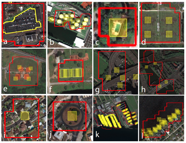
Helping AI Algorithms Build Object Aware Maps of The World · Tomnod (Image Copyright: DigitalGlobe)
Machine Learning & Crowd Sourcing
Given all this data, manual methods to identify and demarcate features of interest is going to be very time-consuming and frankly, out-dated. That’s where AI algorithms and crowd sourcing methods come in. While machine learning algorithms can be very effective in distinguishing between different types of objects it encounters in a satellite imagery, one needs to train it with multiple examples of these objects, in order to improve its performance.
It’s like a typical image processing exercise at the university, where one had to select the training pixels in order to be able to help the system demarcate those objects for us e.g. sand, grasslands, built-up area, etc. The more number of pixels one used to train these classes, the better the classification accuracy and a better looking confusion matrix. While it might be a easy task to select training pixels (samples) if we only had one image to classify or even a few, the problem becomes more time-consuming when you have several thousand images to classify.
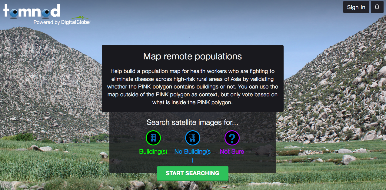
It’s the exact same problem the scientists at DigitalGlobe were facing when they wanted to create object aware maps of the world using satellite data that they collect every day. That’s where the crowd sourcing platform from DigitalGlobe, Tomnod comes to the picture.
Tomnod is a team of volunteers (like you!) who work together to identify important objects and interesting places in satellite images. Use Tomnod to explore the Earth, solve real-world problems, and view amazing images of our changing planet. With the help of millions of volunteer contributions, we fulfill our purpose of seeing a better world – Tomnod.com
Tomnod has already helped DigitalGlobe, collect close to 200,000 training examples for more than 20 object classes! Wow, who knew the crowd sourcing community was this active! Interested in being part of the volunteers, here’s the link to this project – Tomnod.
As we move forward, machine learning and AI methods are going to play an important role in the Geospatial indutry, it’s going to be interesting to see how the Tomnod project helps DigitalGlobe create the next-gen “Google Search Engine” for satellite imagery!
Source: Tomnod Blog – Helping AI Algorithms Build Object Aware Maps of The World