
AI, satellite data to predict blazes ahead of US wildfire season

With COVID-19 threatening to make the already stressful wildfire season worse across the western United States, scientists are turning to satellite imagery and artificial intelligence for better blaze predictions.
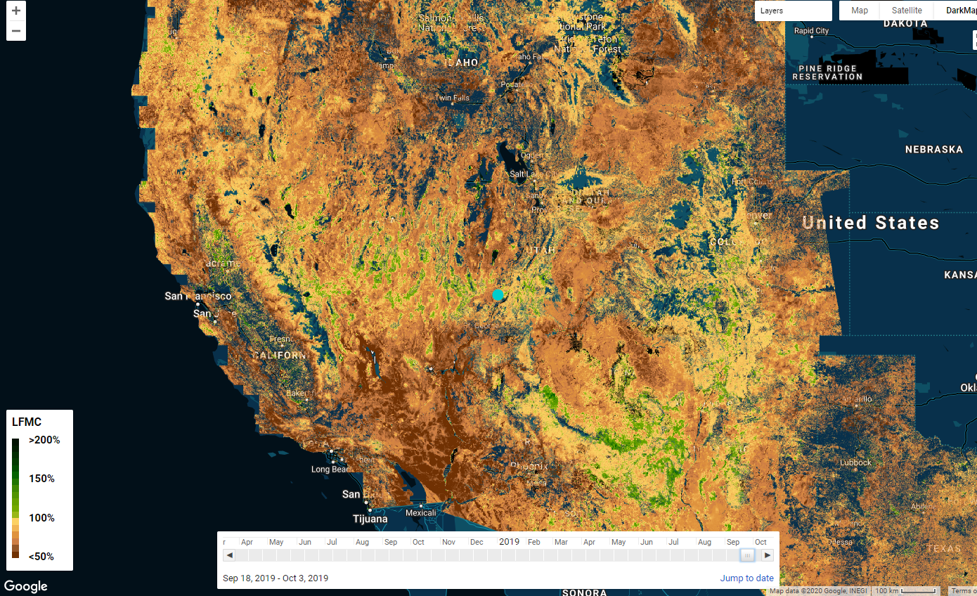
The model’s estimates feed into an interactive map that fire agencies may eventually be able to use to identify patterns and prioritize control measures. Screengrab by Ishveena Singh
Researchers at Stanford University have developed a deep-learning model that can analyze remotely-sensed data to identify and reveal areas that are at the greatest risk of wildfires.
The likelihood that a wildfire would occur in a particular region depends on several factors: the availability of ignition sources, the propensity of vegetation to ignite, and the ease of fire spread once the fuel has ignited. Live fuel moisture content (LFMC), which is defined as the mass of vegetation water per unit dry biomass, is a key underlying factor in all the three components. Higher the LFMC, wetter the vegetation, and lesser the risk of wildfire. And vice-versa.
Typically, to determine the amount of flammable vegetation in an area, fire agencies chop and weigh samples from a small number of trees, dry them out in an oven, and then weigh them again – to see how much water weight the vegetation has lost.
“That’s obviously really laborious, and you can only do that in a couple of different places, for only some of the species in a landscape,” Stanford ecohydrologist Alexandra Konings, points out.
Indeed, the US Forest Service has painstakingly done this job since the 1970s at hundreds of sites across the country and amassed around 200,000 water content measurements for the National Fuel Moisture Database.
Meanwhile, the artificial intelligence system proposed by Stanford researchers estimates fuel moisture from two types of satellite data:
- Measurements of visible light bouncing off Earth
- Synthetic aperture radar (SAR), or measurements of the return of microwave radar signals, which can penetrate through leafy branches to the ground surface
“One of our big breakthroughs was to look at a newer set of satellites that are using much longer wavelengths, which allows the observations to be sensitive to water much deeper into the forest canopy and be directly representative of the fuel moisture content,” Konings tells, explaining how the machine learning model was fed on three years of data for 239 sites across the US west starting in 2015, when SAR data from the European Space Agency’s Sentinel-1 satellites became available.
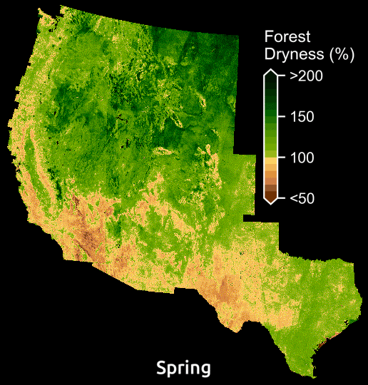
Maps display the amount of water in plants relative to dry biomass across the American WestMaps display the amount of water in plants relative to dry biomass across the American West. Courtesy: Krishna Rao
Admittedly, the model needs more testing to figure into fire management decisions that put lives and homes on the line, but the AI predictions for shrublands are showing promise by matching most closely with the field measurements in the National Fuel Moisture Database.
Shrublands, which occupy as much as 45 percent of the American West, is not only the region’s biggest ecosystem, but it is also extremely susceptible to frequent fires since it grows back rapidly.
According to Krishna Rao, a Ph.D. student in Earth system science at Stanford, the model is already illuminating previously invisible patterns. “Just being able to see forest dryness unfold pixel by pixel over time, can help reveal areas at greatest risk and chart out candidate locations for prescribed burns.”

#Business


Next article
Study Master’s in Mobile Mapping and Navigation Systems to accelerate your career in the Geospatial Industry

A new study program is an answer to the needs of modern engineering which drives the development of technology, including systems of mobile mapping and navigation. The program is planned to last 3 semesters and includes specialized knowledge in the fields of geodesy and navigation, photogrammetry, cartography, spatial information systems and geo-informatics. The main goal is to educate specialists in the design of LBS applications for mobile measuring platforms utilising photogrammetry and remote sensing sensors, positioning and orientation systems and spatial data processing. The studies are conducted in English for students from around the world.
The offered subjects in the area of data acquisition include Mobile Mapping Technologies, Modern Photogrammetry, Positioning Systems, as well as Reference Systems for Navigation, Satellite Navigation Systems and Indoor and Outdoor Navigation. The majority of subjects is strongly connected with algorithmic and application development and is formed by subjects like Programming Language Learning, Algorithms of Navigation Applications, Image Recognition and Deep Machine Learning, Intelligent Transportation Systems and Autonomous Cars, Simultaneous Localization and Mapping, Spatial Analysis and Big Data Mining. There is also a group of subjects connected with visualization and modelling, which includes: 3D Data Processing and Modelling, Augmented Reality, Computer Vision, Mobile and Navigational Cartography. This curriculum is intended for first-degree graduates from the fields of Geodesy and Cartography, Geomatics, Geo-technology, Geo-informatics, Navigation, etc. The first edition of the program will debut in February of 2020. The official recruitment will begin in November/December of 2019. The recruitment information can be found on this web page: https://zk.gik.pw.edu.pl/mmns/Admissions-and-Contact
The development of mobile mapping and navigation technology presents new challenges and opens up opportunities of its use in systems of autonomous navigation i.e. Unmanned Aerial Vehicles (UAVs), autonomous vehicles or indoor navigation systems. This creates new job opportunities and a need for education in the field of design and acquisition, processing and sharing spatial data with the use of mobile platforms. We have invited experts and trainees from the leading companies in Poland and academic institutes in Europe from different fields including mobile mapping, photogrammetry, cartography and navigation. For more information on this program visit this page: https://zk.gik.pw.edu.pl/mmns.