
The Google I/O Developer conference is always an exciting time for us geogeeks and 2018 has been no exception. So, even though developers are still licking their wounds after the brazen changes Google introduced for its Maps API, the developments happening on the core technology front have left us all very, very satisfied. Here’s a lowdown on the new features you can expect to see in your Google Maps app in the coming months:
1) Augmented Reality comes to Street View
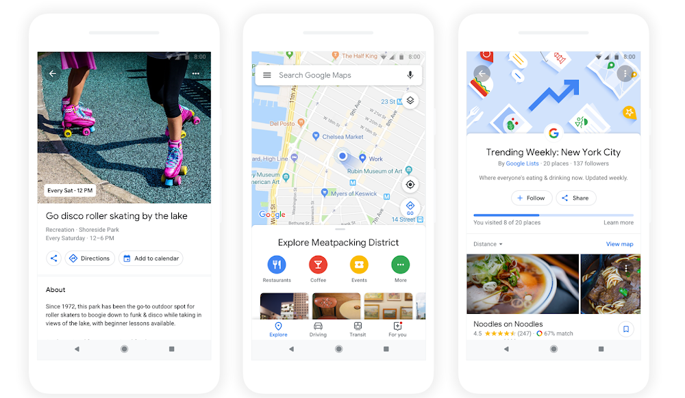
Move over GPS, it’s time for VPS (Visual Positioning System). Combining camera capabilities with Street View, this cool new update will let you see Google Maps’ navigation features inside the camera app. New to a place? You can easily see the names of the places around you along with the directions to your destination. The best part? You don’t even have to wear an additional AR headset!

(Disclaimer: Though Google gave a demo of this technology at I/O, expect to see it in action IRL much later than the features listed below)
2) Stay Updated with ‘For You’
Let’s say you are trying to find a food joint in a new place, or simply looking to discover what’s new in your own locality. This new ‘For You’ tab will act like a social media feed for everything that’s pulling in the crowds in the neighborhood you have chosen.
3) AI-powered Virtual Assistance
If ‘For You’ fails to inspire you for your next outing, the Explore tab surely wouldn’t. In its all-new avatar, Explore has received some pretty awesome features powered by artificial intelligence. There’s a ‘Foodie’ list that will give you top dining options, a ‘Trending’ list to give you the week’s top picks, an ‘Events’ list to tell you what’s happening around you, and an ‘Activities’ list to let you know your options for the day.
4) Get Personalized with ‘Your Match’
Now, let’s say these lists inspired you enough to zero down on a dining option. Once you tap on the outlet of your choice, ‘Your Match’ will come into play and tell you how likely you are to enjoy that place. Sounds cool? Here’s how that will happen: If you have selected any food or drink preferences in Google Maps, the algos will match that against known public information of that business. If you have visited other food or drink options using Google Maps in the past and rated them, these factors will also be counted.
5) Plan a Group Activity
So, the restaurant definitely looks like a good choice and you want to invite your friends to visit see this new place with you. All you have to do is long-press on that place’s listing and a shareable list will pop-up. Want to add more restaurants to this list (you know, because Michael can get fussy about Mexican food)? No problem! Add as many options as you want and let your friends vote for their favorites.
Roll out the update already, Google!

#Business


Next article
Seems like there is no dearth of excitement in the geospatial industry right now! While the businesses providing location services scramble to win market share after Google ruffling quite a few feathers with its recent Maps API pricing model changes, Microsoft has gone ahead and announced the general availability of the new kid on the block – Azure Maps.
Previously known as Azure Location Based Services, the product marks cloud computing platform Azure’s first outing at providing native geospatial functionality. Microsoft says Azure Maps is designed to allow seamless integration of mapping, search, routing, traffic, and time zone queries into enterprise apps. Chris Pendleton, Principal PM Manager at Azure Maps insists that the services will be particularly useful for those engaged in the Internet of Things where location is a foundation for sensor visualization.
So, here are some interesting things you need to know about Azure Maps…
1) Search
The Search service is packed with three major functions: Geocoding, Reverse Geocoding, and Point of Interest (POI) Search. While address-level geocoding is available for 38 regions, for rest of the world, city-level geocoding is supported. In POI Search, users can look for results within a defined geometric area or specify a radius for a ‘nearby’ POI. Further, developers can find points of interest along a specified route as well.
2) Routing
Azure Maps’ Route service goes much beyond just step-by-step navigation. While general route calculation can be optimized for fastest, shortest, or avoidance of highly congested roads or traffic incident, when it comes to commercial routing, the service provides alternate routes made just for trucks. The latter’s results are optimized after taking parameters like vehicle height, vehicle weight, number of axles, and hazardous material contents into consideration.
3) Render
Want to embed a map image into a webpage or app? Azure’s map service will give you high-fidelity spatial information of more than 200 regions across the globe. Available in 35 different languages, the cartography for the service has been designed especially for the enterprise customer. Which means you can render your data atop of Azure Maps without worrying about additional detail bleeding through. You can also use their static image API to generate embeddable map images.
4) Time Zone
Providing localized time zone names for around 50 languages, Microsoft says this service is first of its kind in providing the ability to query time zones and time for locations around the world. Azure Maps Time Zone service also factors in changes for daylight savings while giving users access to historical and future time zone data.
5) Traffic Service
Built in partnership with TomTom, this service allows Azure Maps to offer most-up-to-date traffic information, such as the type of traffic incident and its exact location. Users can natively overlay traffic information atop of the map to view traffic issues quickly and conveniently, including how much time it would take to get out of traffic congestion or the distance and time from the current position to the ‘back of the line’.

6) Azure Maps Pricing
Coming to the pricing, you get 250,000 transactions free per month for Maps and Traffic Tiles – where one transaction is created using increments of 15 tiles. For other services, free transactions are capped at 25,000. After this, every 1,000 transactions will cost $0.50.
So, do Azure Maps sound like a good alternative for Google Maps to you? If not, you can always check out our list of other alternatives here.